As Labor Day recedes sadly into the distance and we come to grips with the fact that, yes, another school year has officially begun, I can’t help reflecting on the pervasive and damaging myth within American educational culture that junior high is a terrible place to be — something to be survived, not enjoyed.
Sure, the sheer size of a big junior high school is intimidating at first. Yes, there are bullies, and they hit harder than they did in grade school. And there’s no doubt that adolescents can be obnoxious and hurtful, especially when it comes to teasing and tormenting their weaker, geekier, or more awkward peers.
But junior high also can be a place for kids to have fun, to mature into their new minds and bodies, to make new friends, and to relish that time of innocence before the reality of working a part-time job or sweating over college applications. Junior high is, in fact, the last sweet time of true childhood — a realization that occurs to me now as a middle-aged parent.
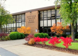 I suppose that my rosy view of junior high is somewhat colored by my own mostly positive experiences growing up in Joliet, where I attended Hufford several, um, decades ago. As a short kid who wore goofy-looking glasses, favored brown corduroys, sported hair that refused to “feather” properly by late 1970s standards, and was universally known as a bookworm, the odds of my fitting in and avoiding physical trauma weren’t exactly favorable. So how was it that I actually enjoyed my junior high school years, let alone survived them with all of my teeth intact?
Here’s the secret.
Early on in sixth grade, I joined the school’s long established and much-ballyhooed Drama Club, which convened during school hours just like band, orchestra, or choir. Every day thereafter, I lived for tenth period, when our teachers Jack Prendergast and John Nordmark brought us into what to me seemed like an entirely different and wonderful place: the World of the Stage.
Sixth through eighth graders worked, learned, and joked together in this alternate world. We practiced monologues and scenes; competed in speech contest every fall; tried to one-up each other at every audition; and put on a fall play and a full-blown spring musical each school year. In the process, we honed our oratory and acting skills and . . . perhaps most importantly . . . learned how to mount the stage with confidence, take risks, and deal with failure.
To this day, I have had few tests of personal courage that matched that of having to kiss the leading lady in our Spring 1981 production of “Bye, Bye, Birdie” in my eighth grade year, while 400 screeching and hooting adolescents raised the roof of Hufford’s auditorium in hormone-fueled delight at the spectacle.
So here is my advice to all the junior high schoolers out there, assuming you’re precocious readers of this blog:
(1) Join something. Band, orchestra, choir, drama, scholastic bowl, chess club, basketball, volleyball, cross country — whatever it is, try it out and see if it suits you. This is a good way to make some friends outside of the hot lunch line.
(2) Be yourself. Just because you join a group doesn’t mean you have to become a sheep. Hey, America is all about celebrating the individual! So I say, go gonzo with that Mohawk.
(3) Don’t take any crap from bullies. Even if you’re small. Remember, little guys are dangerous, especially if they’re smart enough to make big/older friends. (See #1 above.)
(4) Enjoy your time there. I’m sad to report it’ll be over in a blink of the eye. And when you get old like me, you just might miss it.
I am a 1981 graduate of Hufford Junior High School, where I first learned to diagram a sentence, bake a cake, operate a jig saw, draft designs for a building, give a speech, solve algebra equations, and square dance. A version of this essay will appear on 15 Sept 2013 as my regular op-ed column in the Joliet Herald-News.

