The Chicago Park District is now hiring seasonal positions with the Natural Areas Crew for 2025! The Natural Areas Crew is responsible for ecological restoration and management of the Chicago Park Districts prairies, woodlands, and wetlands. Applications are due by Th 1/23/25.
Duties include:
Using conservation and restoration methods to improve the overall quality of natural areas, including mowing, herbicide application, hand pulling, and planting.
Identifying and learning both native and non-native flora relevant to the region.
Trail maintenance, fence repairs, garbage removal, and general park upkeep.
Engaging communities and working with volunteer groups to connect people to nature and promote environmental education.
Pay for the 2025 season is $23.41/hr. Applications are due by January 23rd, 2025.
Questions? Contact Blake Struve (he/him)
Natural Areas Project Coordinator | Chicago Park District
Department of Cultural and Natural Resources
1000 E. Oakwood Blvd | Chicago, IL 60653
Phone: (312) 636-2166 Email: blake.struve@chicagoparkdistrict.com
While Millennials and Gen Zers are leading the way on climate change activism and environmental justice here in 2019, their passion for change and stalwart efforts against seemingly insurmountable barriers are inspired by and built upon the efforts of previous generations of environmental advocates. On such champion — local conservationist, activist, writer, editor, film documentarian, and policymaker Lee Botts (1928-2019) — died this past Saturday in Oak Park, IL.
“Lee Botts was editor of the Herald during the late 1960s implementation of the urban renewal plans,” said Herald Chairman Bruce Sagan, who has owned the newspaper since 1953. “Her objective journalism was a crucial component of the civic discussion during that complex history.”
In 1968, she joined the staff of the Open Lands Project in Chicago. From 1971 to 1975, she was the founding executive director of the Lake Michigan Federation, which is today the Alliance for the Great Lakes. Under Botts’ leadership, the new organization persuaded Mayor Richard J. Daley to have Chicago become the first Great Lakes city to ban phosphates in laundry detergents, led U.S. advocacy for the first binational Great Lakes Water Quality Agreement in 1972, was a key advocate for the landmark federal Clean Water Act of 1972 and played a key role in persuading Congress to ban PCBs via the 1974 Toxic Chemicals Control Act.
After a short stint with the Environmental Protection Agency Region 5 office in Chicago, President Jimmy Carter appointed her to head to the Great Lakes Basin Commission in Ann Arbor, Michigan, in 1977. After the agency was eliminated from the federal budget, Botts held a research faculty appointment at Northwestern University from 1981 to 1985.
She joined the senior staff of Mayor Harold Washington in 1985, organizing the city’s first-ever Department of the Environment. In 1986, with Washington’s endorsement and support, Botts ran for the board of the Metropolitan Sanitary District of Greater Chicago but lost by 2%.
Botts relocated to Northwest Indiana in 1988, where she became an adjunct professor at a local college and joined various boards and committees. While living in Gary’s Miller Beach neighborhood, she began advocating for an idea she’d first written about a quarter-century earlier: the Indiana Dunes Environmental Learning Center, which she helped found in 1997.
An independent non-profit located within Indiana Dunes National Park, the Dunes Learning Center offers year-round environmental education programs and overnight nature-camp experiences for grade-school students and teachers. Today, nearly 10,000 students come to the center each year from school systems throughout Indiana, Michigan and Illinois. Botts initially chaired the institution’s board of directors.
For many years, Botts suggested that the modern history of the Indiana Dunes region could become an engaging documentary film. With director Patricia Wisniewski, she began working on making “Lee’s dunes film” in 2010, writing the film’s script, conducting many of the interviews, leading the fundraising effort and traveling to promote the project, even after she was no longer able to drive her own car.
“Shifting Sands: On The Path To Sustainability” was released in 2016 and won a regional Emmy Award. To date, it has been broadcast on more than 70 public-television stations, included in several major film festivals and screened by scores of local citizens’ groups and public libraries throughout the states bordering Lake Michigan.
Botts was awarded a citation from the United Nations Environmental Program for making a difference for the global environment in 1987, the 2008 Gerald I. Lamkin Award from the Society of Innovators at Purdue University Northwest and honorary doctorates from Indiana University and Calumet College of St. Joseph. She was inducted into the Indiana Conservation Hall of Fame in 2009.
A person who did any one of the above accomplishments would rightly be lauded for the impact of their work on behalf of people and the environment. The fact that Lee Botts did all this and more — through her own will, dedication, and fierce advocacy as well as her ability to connect and collaborate with others — is nothing short of astounding.
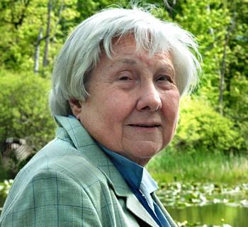
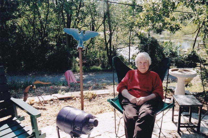
This is a picture of a radical environmentalist: Lee Botts in her backyard at home in Gary, IN (photo provided by Paul Botts, published in the Post-Tribune 6 Oct 2019)
See these sources for more information on Lee Botts:
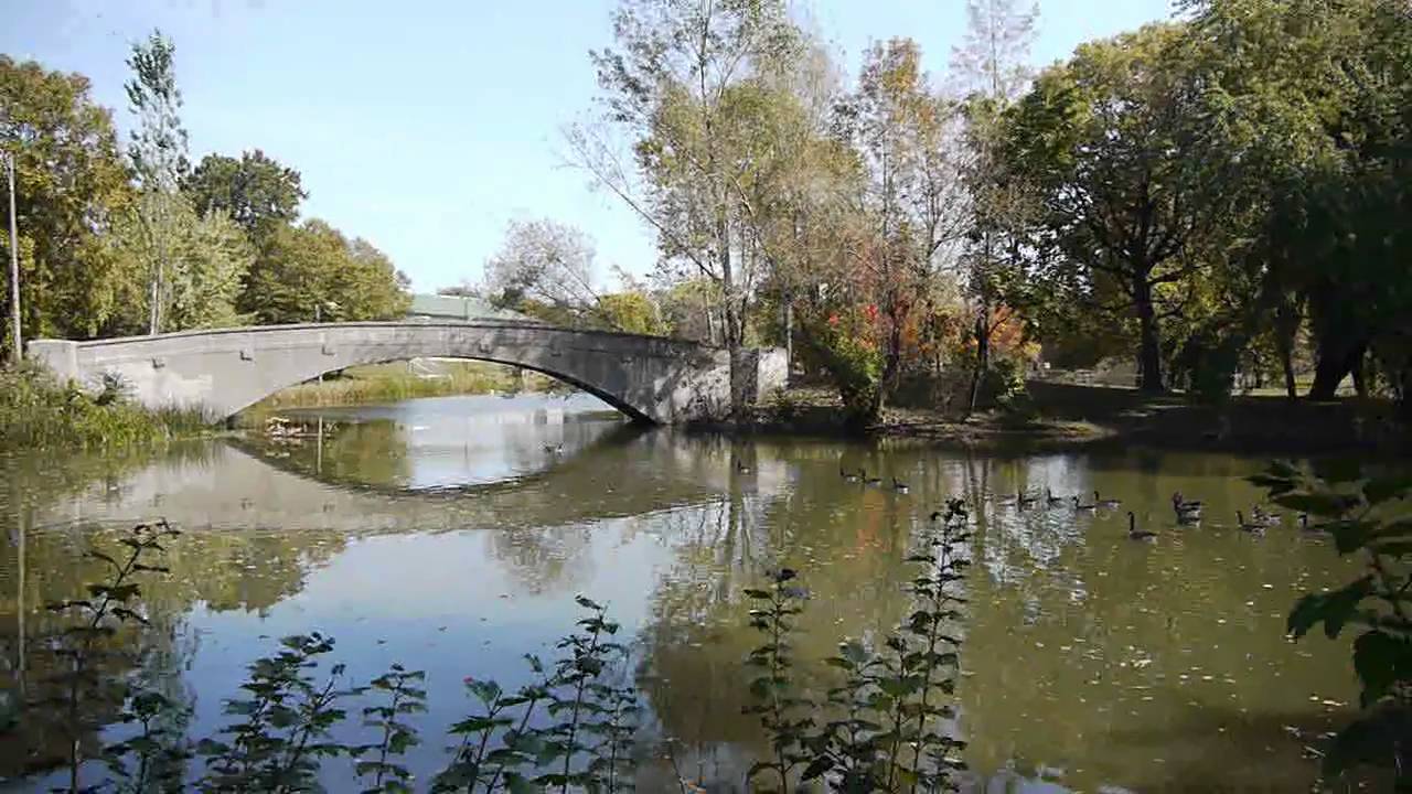
One of the stone bridges over the lagoon at Sherman Park, Chicago IL (source: YoChicago)
This past Tuesday I had the good fortune to go to the Sherman Park branch library of the Chicago Public Library system in order to do an hour-long program on water and sustainability for neighborhood teens. The librarian who invited me, Faith Rice, encouraged me to be as “hands-on” as possible instead of just lecturing, which suited me just fine — so I brought my surface water testing kit, turbidity tube, bucket, and assorted supplies in the hope that we could leave the library and do some sampling of the lovely, meandering lagoon of historic Sherman Park on Chicago’s South Side.
As I made the drive from Roosevelt in the Loop down to Garfield Avenue, it began to rain. Perfect, I thought, for an afternoon dedicated to talking about water — but the downside was that the rain caused some of the teens who walk or ride their bikes to the library to go home early before our 4pm session. Nevertheless, when I arrived I was welcomed by Faith’s colleague, Lala, who got me set up in the lovely old library’s classroom and assured me we could step outside to the park and get a bucket of water for testing.
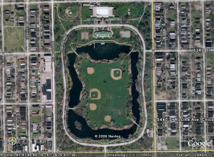
Aerial view of Sherman Park in Chicago (source: Google Earth)
I ended up ditching my planned slide presentation and just having a free-ranging conversation about water with three kids: Destiny, a high school senior; Tiara, an 8th-grader; and Lawrence, another 8th-grader. Despite not knowing me from Adam, they were very talkative and willing to share their knowledge about the water cycle, as I asked them to say what comes to mind when they hear the word “water.” We soon trekked outside with Lala to the nearby edge of the park’s lagoon, where we gathered a bucketful of water to do three trials with our turbidity tube outside in the intermittant drizzle. (Average reading was 9cm or 120NTU, which indicates a high level of turbidity — something obvious just from looking at the murky water.)
We took another bucketful of water back into the library’s classroom to do a few more quick tests before the kids needed to leave by 5pm. As we re-entered, we caught the attention of the security guard, who betrayed her interest in our somewhat noisy (and wet) experiments — so I invited her and an adult patron to join us. They let the kids do all the work, but we also chatted about their ideas and assumptions about the quality of water in the lagoon as well as the ongoing issue of lead contamination of Chicago’s drinking water.
The kids measured the temperature of the water (26 degrees C, a bit high for most aquatic life, but indicative of our near-shore sampling and the hot summer in Chicago); pH (8.9, fairly alkaline but still within an acceptable range); and nitrate (0-0.1ppm, a relatively low level of a nutrient that can cause harmful algal blooms). While we didn’t have time to conduct more comprehensive tests, the kids were able to assess the current water quality of the lagoon as “so-so” — OK in some respects, not so good in others — which pretty much jibes with most of my water quality sampling results on the Chicago River the last several years with my Roosevelt University students.
Beyond those quantitative assessments, though, what impressed me about the afternoon’s adventure was the importance of parklands and water bodies here in the vast urban landscape of Chicago. Just as the Sherman Park branch library is an oasis of education, literacy, and community programming (for kids and adults alike), so too are the meadows, woods, and lagoon of Sherman Park itself a vital natural resource for the neighborhood’s residents. Getting one’s feet a little muddy at the banks of the lagoon taking water samples drives that point home in a tangible (and fun) way.
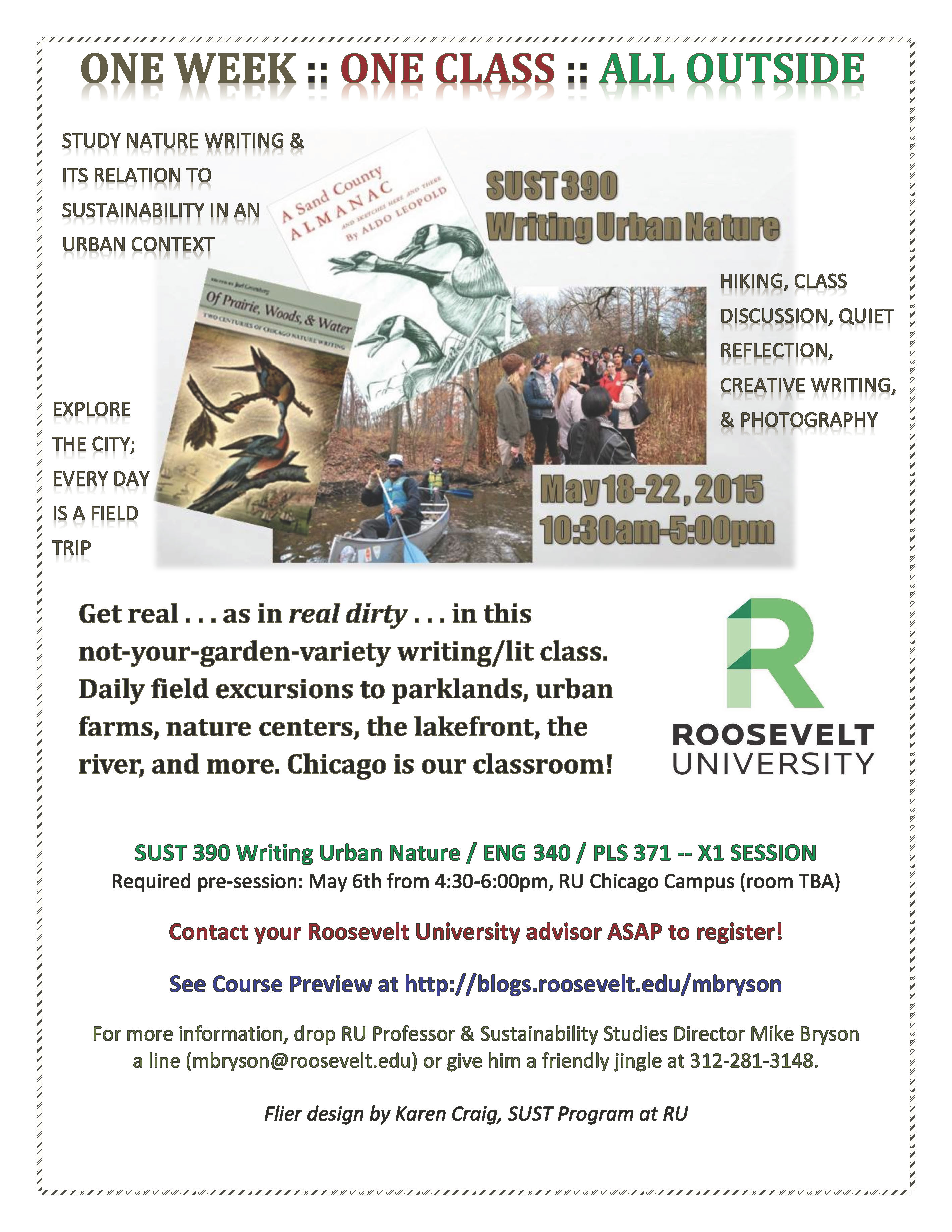
Still plenty of room in this new one-week-intensive summer course! Pre-session is next Wed., May 6th, at 4:3pm in Gage 218. For more detailed information on my summer intensive course, check out this Writing Urban Nature preview; and share a pdf version of the image above via email.
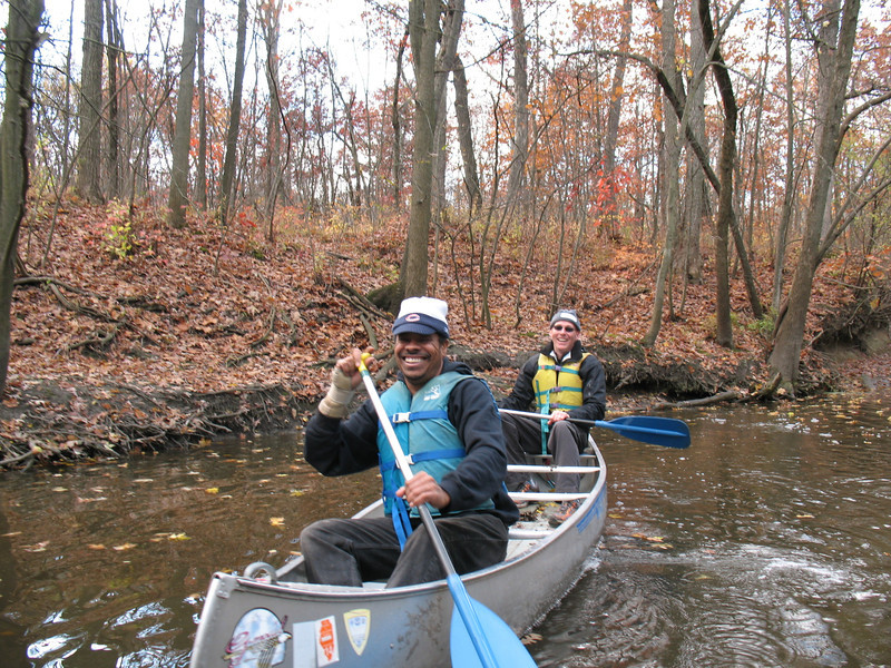
RU students paddle the North Branch of the Chicago River, Fall 2012 (M. Bryson)
This May 2015 one-week-intensive section of SUST 390Writing Urban Nature is an environmental literature and writing special topics course distinguished by in-the-field explorations of various natural and urban environments. The class provides a unique immersive experience in “nature close at hand” at sites of ecological and cultural significance in the Chicago region. Strong emphasis on close observing place and people; walking and exploring landscapes and neighborhoods; and reflecting on / discussing compelling ideas, stories, and images of urban nature, broadly defined.
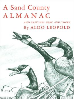
Assigned readings will include selections from May Watts, Reading the Landscape of America; Aldo Leopold, A Sand County Almanac; Joel Greenberg, Of Prairie, Woods, and Water; blogs such as City Creatures and The Nature of Cities; and other texts. The reading list will be distributed well in advance of the class so that students will have time to read ahead prior to the week’s explorations and discussions.
Daily activities will consist of field excursions to sites of interest in Chicago’s urban landscape; discussion of assigned readings; quiet time for personal reflection, journal writing, and photography; and potential service work for local environmental organizations. Students’ daily journal and photo archive will provide material for a personal/critical reflection essay (due one week after the class ends) that incorporates text and image, critically analyzes selections from the course reading list, and reflects on the student’s individual experience in the class. Collectively, the class will produce an online project (“Chicago’s Urban Nature”) as part of the SUST at RU Blog that features creative/reflective writing that reflects upon their experience and incorporates both text and image.
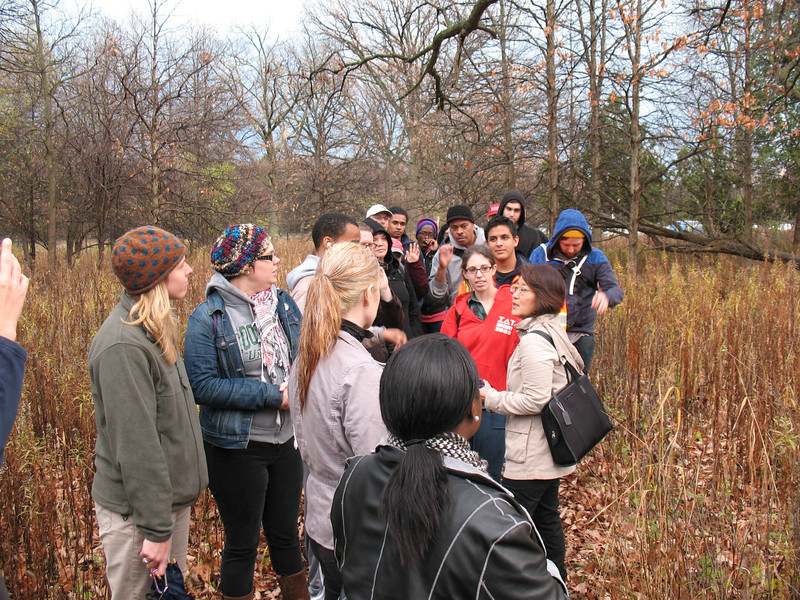
SUST students visit the North Park Village Nature Center, Fall 2012 (M. Bryson)
Potential sites we will explore include Chicago’s lakeshore parklands and public spaces, the Chicago River (on foot and/or by canoe), neighborhood parks of cultural and ecological significance, nature centers on the North and South Sides, selected urban farms within the city, and the natural and industrial lands of the Calumet Region on the far South Side. The week’s schedule is still under development, but the varied locations will give students an opportunity to explore many seldom-seen parts of the city within a unique learning context. Most of these activities will be free, though a small fee may be charged to cover certain trips (e.g., canoe trip on the Chicago River). Public transportation will be used to access most sites. Carpooling options will be discussed at the May 6 pre-session (see below).
Who Should Take this Class
SUST students working at the Eden Place Nature Center on Chicago’s South Side, 2 Dec 2014 (M. Bryson)
SUST 390 Writing Urban Nature is cross-listed with ENG 340 Writing Urban Nature and PLS 371 Humanities Seminar II. SUST majors can take SUST 390 Writing Urban Nature for major credit as a SUST core course, as a Relevant Elective within their major, or as a general elective. Students who have taken a previous version of SUST 390 are eligible to take this version for credit. English majors may use this as an upper-level ENG credit or as an elective course in SUST or ENG. Students in the PLS Flex-Track program may register for PLS 371 for Humanities II credit as an upper-level general education course, or take SUST 390 for elective credit.
Registration Information
SUST 390-X1 Writing Urban Nature — CRN 30666 / Pre-req: ENG 102 with a grade of C- or better
ENG 340-X1 Writing Urban Nature — CRN 30689 / Pre-req: ENG 220 with a grade of C- or better
PLS 371-X1 Humanities Seminar II — CRN 30690 / Pre-req: PLS 370 or concurrent; admission to Flex-Track program for adults or advisor consent
Meets May 18-22 from 10:30am to 5pm at RU’s Chicago Campus. Required pre-session on May 6 from 4:30-6pm, room TBA. Some additional work online required; final assignment due May 29.
For more information, contact Prof. Mike Bryson (mbryson@roosevelt.edu or 312-281-3148).
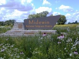
Midewin National Tallgrass Prairie, located just north of Wilmington IL in Will County, is seeking a full-time Assistant Volunteer Coordinator. This position is possible because of a partnership between the U.S. Forest Service and The Nature Conservancy.
To view this job posting and apply, please visit www.nature.org/careers. You can search by using the job ID #41231. All applicants must apply online; Midewin does not accept emailed resumes. Submit your resume and cover letter as one document. All applications must be submitted in the system prior to 11:59 pm Eastern Time on July 16, 2013.
Allison Cisneros – Volunteer Coordinator
The Nature Conservancy @ U.S. Forest Service
Midewin National Tallgrass Prairie
30239 South IL State Route 53, Wilmington IL 60481
Work: 815.423.2149 Cell: 815.474.3808 acisneros@tnc.org
After my sandwich break today while telecommuting from the Joliet Public Library’s Black Road Branch location, I took a postprandial stroll through the marsh at the Rock Run Forest Preserve, which is just to the west of the library.
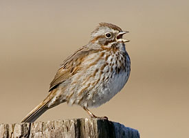
Song Sparrow (Cornell Lab of Ornithology)
Heard one of my favorite sounds of spring: the three-part call of the song sparrow, one of the most eloquent of North America’s songbirds. He might have an understated appearance, this little brown songster — but what a voice! Here’s some info on this aptly-named species, Melospiza melodia, from the Cornell Lab of Ornithology, where you can hear the song yourself and learn more about its biology.
Better yet, get outside where some woods meets a lake, a river, or a clearing, and you’ll probably spot a song sparrow perched on a shrub or a small tree. Or, like me, hear it first.
I received this notice via email from the Friends of Volo Bog environmental stewardship organization. A nice scholarship opportunity for continuing SUST majors looking to supplement their finances for 2013-14.
The Friends of Volo Bog is offering an Entering College scholarship and a Continuing College scholarship for $1,000 each to outstanding students interested in pursuing an environmental career.
To be eligible for the Entering College scholarship the applicant must reside in Lake, McHenry, Kane, Cook, DuPage, Kendall, or Will County, attend a high school in one of these counties, have a minimum B average for the first three years, and plan to attend an accredited college or university. The applicant should be planning to enter a career directly related to preserving the natural environment.
To be eligible for the Continuing College scholarship the applicant must be currently enrolled in an accredited college or university pursing a degree directly related to preserving the natural environment, have a permanent residence in Lake, McHenry, Kane, Cook, DuPage, Kendall, or Will County, have graduated from a high school from one of these counties with a minimum B average, and currently hold a minimum B average in their college studies.
The Friends of Volo Bog is a not-for-profit 501(c)(3) organization, dedicated to promoting citizen awareness of the local natural heritage of Volo Bog State Natural Area, portions of which are dedicated state nature preserves, and to preserving the same through special events, educational and training programs, acquisitions of properties for such purposes and taking whatever steps deemed necessary to insure the continued care and preservation of Volo Bog State Natural Area as a natural site.
This past Saturday, students in my SUST 220 Water and PLS 391 Natural Science seminars at Roosevelt University joined me for an urban ecology adventure on the Upper North Branch of the Chicago River. We convened mid-morning at Linné Woods, a woodland site locatedin the Cook County Forest Preserve system in Morton Grove, IL, where we met up again with Mark Hauser and Claire Snyder, naturalists from Friends of the Chicago River, for a water quality sampling session of the river where it flows past the lovely picnic grounds in Linné Woods.
Claire Snyder and Mark Hauser, naturalists from Friends of the Chicago River (M. Bryson)
While this was the second go-round for my 220 Water students on field sampling (our first session was further downstream on the North Branch, at West River Park in Chicago), the students from my natural science seminar were new to this exercise; however, after three weeks of being introduced to issues and concepts in urban ecology (from biodiversity to climate change), they were ready to get out in the field and get their hands dirty.
Breaking up into different teams, we measured key chemical indicators such as temperature, turbidity, pH, dissolved oxygen, nitrate, phosphate, and total dissolved solids; and wading into the river with D-nets to scrape up mud in search of macro-invertebrates (worms, leeches, crawfish, snails, damselfly nymphs, etc.), we also garnered a biological snapshot of the river’s relative quality.
Down from the meadow and near the riverbank, Claire discusses the various chemical and physical tests we’ll perform to assess the water’s overall quality: pH, nitrate, phosphate, dissolved oxygen, temperature, total dissolved solids, and turbidity. Half our group work on gathering these measurements, while the other half work on the biological survey with Mark. (M. Bryson)
Taken together, these two approaches give us an in-the-moment (chemical) and over-the-longer-term (biological) assessment of the ecological health of the North Branch. This is because while the chemical profile of a river can change day to day — even hour by hour — depending upon the weather and various inputs into the watercourse, the biological community in the river’s benthos is stationary; and some of organisms that live there have been there awhile.
Our quality results were decidedly mixed.The chemical profile we established had some indicators looking rather good, such as a low nitrate reading of 1.3ppm and a fairly neutral pH of 6.5; turbidity levels were also reasonable. The low nitrate reading makes sense, given that in this area of the northern suburbs north of Dempster Ave. (Glenview, Golf, Morton Grove), communities use a separate sewer system, so wastewater treatment plants are not burdened by high inputs of stormwater run-off, and the waterways do not received Combined Sewage Overflows as they do in older suburbs and the city. Moreover, there is not much, if any, agricultural land in this part of the river’s watershed, meaning that fertilizer run-off from farm fields is not an issue.
Hunting for macro-invertebrates in the river’s water and sediments, under rocks, and along the shoreline (M. Bryson)
On the other hand, phosphate levels were rather high at 0.7ppm and the all-important indicator of dissolved oxygen was fairly low (at 7ppm and 60% saturation), posing challenges for many types of organisms to thrive in the river’s watercolumn and benthos. All in all, we calculated a “Quality Index” grade of 68% on our collective chemical analyses, or if you’re using a letter-grade system, D-plus. Nothing to write home about, despite the lovely, even bucolic, scenery in this part of the Chicago River which follows its natural watercourse and winds through forest preserve land. This assessment was echoed rather closely by our macro-invertebrate survey, which identified 8 different taxa of organisms, ranging from several that are “modertely intolerant to pollution” to four that are “fairly” to “very tolerant” of impaired water quality. Our Water Quality index of 2.6 was on the low end of “fair” in terms of biological diversity (call it a C-minus).
Measuring stream flow (M. Bryson)
Finally, our group waded into the stream and use measuring tape, rules, a stopwatch, and a collection of sticks to calculate the stream flow rate. The trick here is to stake out a place where the width and depth of the river is known, and then release the sticks in the current. Students time how long it takes each stick to travel a given distance (here, 40 feet) and then calculate the stream flow (cubic feet/second) accordingly. Our result: a stream flow rate of 98 cubic feet per second.
Curious readers can review our original field data sheets and calculations here; and for photos of our water sampling activities, see this online slideshow.
Here on the upper North Branch, the river follows its natural course and thus has lots of twists and turns. It took us about two hours to paddle five miles. Lots of overhanging branches required careful maneuvering. (M. Bryson)
After a picnic lunch, we used several of our vehicles to shuttle our group up to our canoe launching spot five river miles north, at Blue Star Memorial Woods in Glenview. Here we met up with Dave Rigg and his fellow volunteer canoe guides from Friends of the Chicago River, who would lead us on an intimate exploration of the water, woodlands, and wetlands of the West Fork of the Upper North Branch of the Chicago River — one of the most scenic and naturalistic stretches of the entire Chicago River system. Dave and Co. gave the many inexperienced but enthusiastic paddlers in our group a paddling lesson, and once outfitted with our safety gear, paddles, and a canoe partner, we hit the water for what would be a two-hour downriver journey in utterly perfect October weather.
Ron and Ken getting ready for our first portage (M. Bryson)
The majority of this trip runs through forest preserve property, with the notable exception of the Chick Evans Golf Course that straddles the river where the North Branch splits into its Middle and West Forks. The result is that we traveled along the natural course of the stream, mostly unchanged from before the time of European settlement, with all its twists and turns and with a wide buffer zone of floodplain forest. The heavily vegetated riverbanks proved to be a stunning contrast to the reinforced concrete and rusty steel that encases much of the Chicago River further south in the watershed.
Besides navigating all the twists and turns of a sometimes narrow and always lovely river channel, as well as ducking under overhanging branches, we had to negotiate two portages — the first for a couple of large downed trees, the second for a dam that is slated by the Cook County Forest Preserve for future removal, since it no longer serves a practical purpose and has deleterious impacts upon the river’s flow, water quality, and recreational value.
Portaging around some downed trees (M. Bryson)
These proved to be an interesting and fun challenge, though — especially given our previous contemplation of the long portages done by explorers and Native Americans between the West Fork of the South Branch, through the wetlands of Mud Lake, to the Des Plaines River (a place now commemorated by the Chicago Portage Historic Site).
More photos of our canoe trip can be seen in this online slideshow. In the near future, I’ll post some additional comments about the state of the river and its surrounding landscape that we observed on this trip.
This dam is a significant obstacle for canoeing humans and swimming fish; Friends of the Chicago River advocates its removal, the sooner the better. (M. Bryson)Heading downstream on the Upper North Branch, about a half-mile from our destination in the Linné Woods forest preserve in Morton Grove, IL (M. Bryson)