Two weeks ago my wife and I took a rare break from our humdrum lives as sleep-deprived and chore-obsessed parents of small children, and indulged ourselves in a night’s entertainment at Joliet’s historic Rialto Theatre, which for one glorious and side-splittingly hilarious evening hosted comedian Jerry Seinfeld for two high-profile performances.
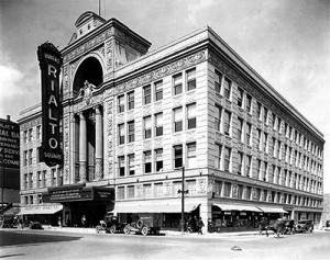
The Rialto Theatre, Joliet IL, c. the late 1920s (Photo: Legends of America)
When tickets for Seinfeld’s appearance went on sale several weeks ago, the town buzzed with excitement at the prospect of the wise-cracking New Yorker gracing my hometown’s most fabulous stage. I should know, since I stood in line mighty early to get fourth row tickets for my wife’s birthday present.
Such was the overwhelming demand for the show that later that day a second performance was announced — and its tickets sold like hot cakes, too. On performance night, the Rialto brought well over 3,500 people into downtown Joliet ready to have some laughs and spend money — a fact to be noted with some measure of respect.
I should elaborate. Random readers from outside the area might harbor the mistaken impression that as the fourth-largest Illinois metropolis, Joliet possesses a vibrant downtown nightlife scene.
Shockingly, though, this is not the case. As we natives well know, about the most glitz and glamour you’ll get downtown on non-Rialto performance nights is the flashing blue light emanating in a menacing Big Brother-like fashion from the Homeland Security cameras mounted on buildings throughout the city’s central district.
That’s why we need people like Seinfeld to come to town occasionally, jazz up the scene, and make us forget temporarily that we live in such a sleepy, quiet, middle of the road, surveillance-camera-infested place. Not that there’s anything wrong with that.
But now that the raucous laughter from Seinfeld’s routine has died down, we should contemplate something far less funny. With about $7 million more in reserves within the overall 2012 budget projections than previously estimated during the summer, the City Council still cut $100,000 of its support for the Rialto and $166,000 more from other local arts organizations — specifically, the Billie Limacher Bicentennial Park (which hosts community theater and other events at its indoor auditorium and outdoor stage) and the Joliet Area Historical Museum.
Consider that hundreds, if not thousands, of Rialto patrons that night went out to dinner (and/or to the casino) before or after the shows and fed generous wads of their hard-earned money to the local economy. I can testify that we enjoyed a phenomenal meal at a downtown establishment that was absolutely hopping during “wave two” of Rialto-stimulated business.
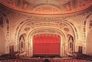
The auditorium at the Rialto (Photo: Legends of America)
Consider that instead of mocking our nightlife-challenged burg, Seinfeld took pains to declare sincerely that the Rialto is one of the most beautiful and glorious performance venues he has ever played. (And does anyone seriously think he would come to Joliet were the Rialto not here?)
Finally, consider which is funnier: a Jerry Seinfeld stand-up comedy performance, or the three-ring circus of Joliet’s ongoing 2012 budget deliberations?
This fellowship opportunity just crossed my desk. I’m sure the application process is rigorous, but the SUST major at RU qualifies as an eligible program of study, according to my quick scan of the applicant requirements. If you’re entering your junior year (approximately) in the program and have an interest in working at the EPA in the summer, check this out.
Fall 2012 EPA Greater Research Opportunities (GRO)
Fellowships For Undergraduate Environmental Study Application Deadline: December 12, 2011
EPA, as part of its Greater Research Opportunities (GRO) Fellowships program, is offering GRO undergraduate fellowships for bachelor level students in environmental fields of study. Subject to availability of funding, and other applicable considerations, the Agency plans to award approximately 40 new fellowships by July 30, 2012. Eligible students will receive support for their junior and senior years of undergraduate study and for an internship at an EPA facility during the summer of their junior year. The fellowship provides up to $19,700 per academic year of support and $9,500 of support for a three-month summer internship.
Chicago mayor Rahm Emanuel’s recent proposal to jack up city water rates is guaranteed to make most Chicago residents grouse. After all, Chicagoans have been used to cheap and plentiful water for decades. Not too long ago, water fountains in the city’s parks used to run continuously from Memorial Day to Labor Day, perhaps because installing push-button valves was too much trouble — or because water was considered to be practically free. Moreover, most residents and businesses didn’t even have water meters regulating their water usage. Talk about an open tap!
Those days are about over, thankfully, because from a sustainability standpoint, Chicago’s longtime water profligacy is almost as embarrassing as its inability to implement an effective solid waste recycling program or its propensity for dumping non-disinfected wastewater into its rivers and canals.
So while most citizens will grumble about the rate increases on the horizon, forward-thinking institutions like the Center for Neighborhood Technology are singing a different tune:
The decision was unveiled in the city budget proposal for 2012 to the Chicago City Council today. Among the new initiatives it puts forward is an increase in the annual fee for water and sewer services. The water fee for property owners would increase by 25 percent next year and would begin to charge institutions, such as CNT, for water services that have historically received those services for free.
CNT’s Vice President of Policy Jacky Grimshaw served on the mayoral transition committee that recommended it to him. “Equitable and accurate rates for usage is essential for both system efficiency and managing long-term operational costs associated with water services in the City,” the transition document states.
As a leader and proponent of stormwater management techniques, such as green infrastructure, CNT and its Water program staff look forward to working with the mayor to ensure innovative, sustainable stormwater management measures are a significant part of the City’s water infrastructure modernization effort.
This coming spring semester I will be offering the inaugural section of SUST 350 Service and Sustainability at the Chicago Campus. The specific course theme is Urban Farming, Community Development, and Social Justice.
Title/number: SUST 350 Service and Sustainability (section L10)
Semester offered: Spring 2012 (initial offering)
Campus: Chicago
Day/time: Wed 3-5:30pm
Pre-req: UWR
Text: Lorraine Johnson, City Farmer: Adventures in Urban Food Growing (Greystone, 2010, paper, ISBN 9781554655190) — on order at the RU bookstore
SUST majors and minors may take this class to fulfill an upper-level SUST requirement, but 350 also is open to students at large who need a general education course or desire elective credit.
Introduction to the Course
SUST 350 focuses on one of sustainability’s “Three Es” — social Equity — within the broad context of Environmental stewardship and Economic development. Students will learn about one of the most important components of sustainability — food production and consumption — in the context of urban neighborhoods and ecosystems.
Chicago Lights Urban Farm (M. Bryson)
By doing hands-in-the-dirt labor at Chicago Lights Urban Farm on the city’s near-North Side, students will gain direct knowledge of contemporary organic/urban agricultural systems as well as learn about pressing urban social justice issues such as food deserts, gentrification, pollution, environmental racism, and persistent poverty. Initial class meetings through February will be at RU’s Chicago Campus, while subsequent class meetings will take place at the farm.
Once established at the farm site in mid-March, Roosevelt students will work side-by-side with Cabrini-Green neighborhood youth in a unique reciprocal learning opportunity. Participants in the Chicago Lights Youth Corps program (14-21 age range) work as job trainees at the farm 9 hours/week during the school year and 20 hours/week during the summer.
Compost Bins at the Chicago Lights Urban Farm (M. Bryson)
They acquire skills in urban agricultural production (composting, soil management, seedbed planning, hydroponics, organic pest management, harvesting, etc.) and economy (packaging, marketing, distribution, and sales). To the extent that Roosevelt students are newcomers to these activities, they will be learning skills from the Youth Corps kids as well as from the urban farming experts.
An urban farm is about food, but so much more besides. The Cabrini-Green community is an economically stressed neighborhood that has gone through dramatic and wrenching changes as high-rise public housing has been demolished, residents have been displaced within and without the community, and gentrification proceeds at a rapid pace — even as crime and poverty persist. Here, an urban farm is a source of freshly grown, organic produce; a training ground for local youth in need of practical job skills; a stop valve in the Cradle-to-Prison pipeline; a gathering place for people of all ages in the community for physical exercise, informal education, and social events (such as the annual Fall Harvest Festival held on-site); a demonstration site for sustainable agricultural techniques; a model of economic development on a local, sustainable scale; and a means of reconnecting urban folk to the natural world. More generally, in urban areas starved for jobs, green space, safe outdoor gathering places, and fresh quality food, these small-scale farms productively and powerfully address the need for social equity and progressive change.
Partner Organizations: Chicago Lights Urban Farm and Growing Power
The Chicago Lights Urban Farm is one wing of the Chicago Lights Community Outreach Organization on Chicago’s near-North Side, and is located at 444 W. Chicago Avenue, the south end of the Cabrini-Green neighborhood.
Cabrini-Green row houses as seen from the north edge of the Chicago Lights Urban Farm (M. Bryson)
Formerly known as the Chicago Avenue Community Garden, it began in 2003 as a modest collection of raised-bed planters covering the cracked blacktop of an abandoned basketball playground. Since then, the farm has expanded and diversified its operations with the help of Growing Power, a nationally-recognized urban farm initiative based in Milwaukee that has established satellite operations in several Chicago neighborhoods (including Cabrini-Green, Altgeld Gardens, Grant Park South, and Bridgeport). The mission of the farm is to “empower . . . youth and community residents in the Cabrini-Green neighborhood to have increased economic opportunities through access to organic produce, nutritional education, and work force training” (Chicago Lights “Urban Farm”).
Field Trips in Urban Ecology
SUST 350 Service and Sustainability provides an ideal context for field-based learning experiences that connect progressive social/environmental action to sustainable community development. While the Chicago Lights Urban Farm itself is a quintessential example of such a field experience, a selection of well-planned day trips to other sites will broaden that learning experience for RU students as well as provide a rare opportunity for the farm’s Youth Corps participants to leave the confines of their home neighborhood, see other parts of the region they have little to no familiarity with, deepen their understanding of urban ecology, and personally connect with the varied and surprisingly engaging forms of the region’s urban nature. In this expression of reciprocal learning, RU undergrads and Youth Corps students will be learning together in the context of adventurous new experiences, a process necessitating team-work and producing a profound sense of personal accomplishment.
Planned field trips tentatively include a tour of urban farms sites in Chicago, the Growing Power flagship farm in Milwaukee, the South Branch of the Chicago River, and/or the Indiana Dunes. See this page for accounts of recent student field trips in my SUST courses.
On Thursday, Oct. 13th, I took some time away from my normal professorial duties to attend a lunchtime forum entitled “Chicago’s Water: Protecting Our Precious Resource,” sponsored by the Chicago Council on Science and Technology. The event was held in the 18th floor “Wolf Point Ballroom” in the Holiday Inn Chicago Mart Plaza, literally right off that parking lot that sits on Wolf Point. Floor to ceiling views of the Chicago River and the skyline made for a dramatic setting for the event and the ensuing conversation about the history and future of water management in Chicago.
Combined Sewage Outfall on the Chicago River, in the Loop (M. Bryson)
I couldn’t help but notice the remarkably clear view of the Combined Sewage Outfall (CSO) location where my students and I rafted up our canoes the previous weekend in the Loop and discussed the impact of stormwater overflows of untreated wastewater on the ecology of the Chicago River. It was both odd and inspiring to view that location from up high, only a few days later.
This exceptionally interesting forum featured a keynote address by Debra Shore, an Metropolitan Water Reclamation District commissioner who, unlike most commissioners past and present, actually has a long track record in environmental conservation and advocacy. She is one of the drivers of the recent turnaround in MWRD policy with respect to the disinfection of wastwater. Shore’s presentation highlighted the history of Chicago’s development and its relation to the river, the technological changes that have been wrought upon the latter, the key issues facing us in the 21st century (water quality, Asian Carp, hydrological separation, etc.), and a broad question at the end: “Can Chicago become Nature’s Metropolis for the 21st Century?” In the latter, she implied that how we manage the river will be a large part of the answer to that question.
One key theme that repeatedly came up during the forum’s dialogue was the notion of separating the watersheds as a way to improve water conservation and prevent invasive species (notably the carp) from entering the GLs. Surprisingly, none of the engineers on the panel or in the audience claimed that such a separation was technically impossible, or even too costly to attempt. What they repeatedly cited was the need for the political will and creation of effective avenues of communication and collaboration to do it. If that happened, then the technology could be brought to bear productively. This view was even espoused by Dick Lanyon, the longtime engineer for and then manager of the MWRD who retired in 2010 and who was at this meeting (coincidentally, I sat next to him and got to bend his ear for several minutes after the program). Lanyon is a key source about water management in the Chicago region in Peter Annin’s 2006 book, The Great Lakes Water Wars .
Another issue that was discussed was the status of the current studies underway to assess the feasibility and impacts of hydrological separation. The Army Corps of Engineers’ study was cited several times, favorably, despite it’s rather slow projected timeline that has raised the pique of neighboring Great Lakes states; and Tinka Hyde, the EPA rep, noted that USEPA was collaborating with the Corps on this process.
One vision of how the hydrology of the Chicago Region might be transformed by re-separating the Great Lakes and Mississippi River watersheds (Milwaukee Journal-Star)
Those interested in following up on the status of the GLC’s planning process, as well as learning more about the environmental and ecological prospects of hydrologically separating the Great Lakes and Mississippi River watersheds can read more about it here and/or attend a public webinar on Oct. 24th for the GLC’s Chicago Area Waterway Study.
Wolf Point, the Chicago River in downtown Chicago (M. Bryson)
Such a vantage point affords a unique perspective on the ways in which we use and abuse water, and suggests that we need science, policy, and active citizen engagement to forge a more sustainable future for this much-maligned yet storied river.
On Saturday, October 11th, students in my SUST 220 Water and PLS 391 Seminar in Natural Science classes at Roosevelt University took a canoe trip with me on the North Branch of the River, from Goose Island on the near-North Side of the city to Wolf Point in the heart of Chicago’s Loop — the place where the North Branch meets the South Branch, and ground zero in the history of Chicago’s development from a frontier town to a world metropolis. Our trip was led by expert river guides with the Friends of the Chicago River organization, which has long advocated for the conservation of the river and helped raise its public profile since the late 1970s.
Launching canoes at the North Avenue Turning Basin (M. Bryson)
This was the fourth such trip I’ve taken with my RU students since the spring of 2009, the previous three trips taking place on Bubbly Creek, a notoriously-polluted tributary of the South Branch that for many decades absorbed the waste from the Chicago Stockyards. These field experiences give us a chance to explore urban nature first-hand and think about
how water moves through those ecosystems and sustains their biotic communities;
what kinds of pressures urban or suburban development exert upon these ecosystems;
the impact of such pressures on water quality, flooding, etc.;
conservation and/or restoration strategies that can improve the quality and sustainability of these aquatic ecosystems;
the significance of water quality to the overall sustainability of urban systems, both in terms of nature and people.
Our trip began at a canoe/kayak launch site at the turning basin at North Avenue, the widest spot along the entire Chicago river system. We proceeded down the North Branch, which runs along the west bank of Goose Island — itself a fascinating place in Chicago’s geographic and cultural history that was made an island when industrialist (and later Chicago’s first mayor) William Ogden had a canal dug to the east to excavate clay for brickmaking and to increase the area’s industrial waterfrontage.
A barge near the Morton Salt Company distribution facility, one of the many industries on the North Branch (M. Bryson)
Once home to Irish immigrants who kept geese and other livestock on their property, Goose Island has seen successive waves of industry and residential development over the decades; in this sense, it is a microcosm of Chicago’s own dynamic development as an industrial city. Since the late 1990s and early 2000s, it has become a thriving Planned Manufacturing District.
As we paddled southward toward Chicago’s Loop and passed the southern tip of goose Island, we learned to keep well to the right of the river channel to avoid the many tour boats and private craft that ply these waters. The presence of many diverse watercraft on the river testifies to its importance as a cultural and recreational amenity as well as tourist attraction — all of which have positive economic impacts for the city. The water here offers stunning views of bridges, factories, residential developments, and other waterfront properties — such as the massive Montgomery Ward catalog warehouse built in 1908 — which together constitute a colorful tapestry of the urban landscape.
The 2.3 million-square-foot Montgomery Ward warehouse (M. Bryson)
The presence of urban wildlife in the river corridor, including numerous Canadian geese and Mallard duck sightings as well as evidence of beaver activity, highlight the river’s identity as a living ecosystem and value as wildlife habitat. This green face of the river was particularly evident in the North Branch Canal (east of Goose Island), through which we paddled on our way back from Wolf Point.
Those ecological musings are complicated by consideration of the many Combined Sewage Outfalls (CSOs) that exist along the riverbank, outlets that frequently release untreated sewage directly into the river in times when precipitation exceeds a certain threshold (about a half-inch, depending upon size of the area experiencing rainfall). These outfalls are not confined to industrial sections of the river; 265 of them occur all along the length of the Chicago Area Waterway System (CAWS),
Combined Sewage Outfall on the Chicago River, in the Loop (M. Bryson)
including this industrial yet scenic stretch of the North Branch and at the confluences of the North and South Branches in the Loop. Paddling near such an outflow is a disquieting and disturbing experience, as it brings one face-to-face with the question, “where does our waste go when we flush our toilets?” The answer: right here, quite often.
Indeed, the fecal coliform test we performed later at our canoe launch site confirmed the presence of (though did not quantify) coliform bacteria colonies in the water, which are indicators of fecal coliform — despite the fact that it had not rained in several days prior to our trip. Students also performed a variety of other water quality tests for physical and chemical variables such as temperature, turbidity (cloudiness), pH, hardness, dissolved oxygen, nitrate, phosphate, and chlorine. (You can view a summary of our results here as a pdf.)
Such a profile gives us a snapshot of the water quality at a given moment in time. In this case, overall quality was deemed fair to decent by such measures as temperature, pH, and dissolved oxygen; but elevated nitrate and phosphate levels (nutrients that result from industrial and urban pollution that can cause algal blooms and subsequent oxygen depletion) as well as the water’s fairly turbid nature and the definitive presence of coliform bacteria show there is much room for improvement. Had it rained that day or the previous day, many of these chemical indicators would’ve been measurably worse. Fortunately, the Metropolitan Water Reclamation District (MWRD) has recently moved to begin planning a final stage of disinfection for treated wastewater at two of its treatment plants, a move that will certainly lessen the chronic bacterial contamination of the water.
Heading south into downtown Chicago on the river; Wolf Point and the skyline (M. Bryson)
Paddling a polluted urban waterway is decidedly much different than journeying along a pristine stream in an uninhabited wilderness. But it may be an unparalleled way to way to experience a city’s landscape and to contemplate the complex processes of urban ecology represented by the movement of water with that landscape.
After a summer of disconcerting inaction on Joliet’s $23 million shortfall for 2012, budget deliberations in Joliet’s City Hall have really heated up.
Mayor Tom Giarrante’s proposed plan combines tax hikes, service cuts, pension payment restructuring, and planned negotiations with employee unions as a means of bringing down expenditures; and the Council, much to the delight of Joliet residents, has voted to raise sales and utility taxes in order to generate more revenue.
Getting an inordinate amount of attention in the local press as well as in Council deliberations, though, are potential cuts to Joliet’s less-than-lavish support of the Rialto Square Theater, the Joliet Area Historical Museum, and Bicentennial Park. The mayor proposes relatively modest decreases for these important cultural institutions, while District 1 Councilman Larry Hug advocates slashing city support entirely.
Hug’s attitude is hardly surprising. Whenever economic times get tough, public expenditures on the arts always come under the gun. But the reasoning behind these potential cutbacks is both mathematically misguided and philosophically impoverished.
Let’s do the math first. The mayor’s proposed cuts to the above arts organizations total $266,000 — less than two percent of the city’s $17 million gap in operating expenses. Giarrante’s strategy here is plainly symbolic: while such reductions are admittedly ineffectual because they’re so small, they demonstrate his willingness to make tough decisions across the board.
Ironically, the draconian “cut everything” approach espoused by Hug would not generate all that many savings, either, and could potentially hurt the local economy. Take the Rialto: eliminating its $700,000 of city support trims only four percent from that $17 million shortfall. Yet that would be potentially devastating to the Rialto’s always precarious operating budget, and thus jeopardize the $7.5 million of local economic activity it generates annually.
But let’s also think beyond mere numbers. What would Joliet be like without Bicentennial Park’s music concerts, dramatic productions, and cultural festivals? Without the rich perspective on the our area’s culture and history provided by the much-lauded Historical Museum?
How would the otherwise depressing and downtrodden downtown landscape look without the glitz, energy, and architectural pizazz of the iconic Rialto, Joliet’s only serious venue for nationally-renowned live entertainment?
Oh, sure, life would go on. The garbage would be picked up (on the street, not in the alley), sewage would be processed (in most neighborhoods, anyway, though not necessarily the Ridgewood area on the city’s East Side), and the lights would stay on in City Hall. But a culturally-impoverished existence in which the arts are devalued and unfunded is neither desirable nor acceptable in a city of our size and aspirations.
The question we should be asking, then, is not how much we can slash and burn the already paltry public support of our cornerstone arts organizations and cherished cultural institutions. It’s rather this: what kind of city do we want to live in?
This October marks a couple of fascinating and educational events related to water. These would make excellent field trip alternatives for students in my PLS 391 or SUST 220 classes this fall, as well as interesting forums for anyone interested in the sustainability of Chicago’s water supply and the flooding issues impacting Illinois communities along the Mississippi River.
On Thursday, Oct. 13th, the Chicago Council for Science and Technology will present a luncheon panel discussion entitled “Chicago’s Water: Protecting Our Precious Resource.” From the program’s promo:
Invasive species have destroyed the balance of the Great Lakes ecosystem and threaten further environmental and economic hardship. The Chicago River is still a conduit for periodic releases of raw sewage and suffers from the scars of an unregulated industrial past. Climate change may create more severe storms, exacerbating flooding problems in the region. Hundreds of millions of gallons of water are withdrawn from Lake Michigan every day, used once, and discharged into the waterways. Water supplies are diminishing in the suburbs. Commissioner Debra Shore of the Metropolitan Water Reclamation District will highlight the urgency and scale of these problems and the need for a grand vision of water management. Also, a panel of experts representing different point of views will discuss the potential roles played by government, industry, academia and private citizens to better manage and sustain our water resources.
On Friday, Oct. 21st, the College of Du Page in Glen Ellyn, IL, will host the Mississippi River Basin Flood of 2011 Symposium from 9am to 2:30pm. The day’s program features expert speakers and multimedia presentations on past Mississippi River floods as well as detailed analysis of the 2011 flood event, with scheduled sessions on flood-producing weather patterns, flood monitoring technology, flood mitigation, and floodplain map development. For more detailed information on this free event, see the official flier (pdf) from the CoD Department of Earth Sciences.
The Chicago River has been in the news quite a bit these last few months, and for a waterway long treated as a transportation corridor and sewage receptacle, its future is looking brighter — even as city officials, water quality experts, wastewater treatment engineers, and environmental activists admit there’s a long, long way to go. Today on public radio WBEZ’s local affairs radio show, Eight Forty-Eight, the Chicago River was a main topic of conversation between host Alison Cuddy and Henry Henderson of the Natural Resources Defense Council. Henderson was the first head of Chicago’s Department of Environment, an agency that ironically may come under the chopping block in Mayor Rahm Emanuel’s recent plans to address major budget shortfalls. (A prospect which illustrates that even as progress can be make on one environmental front, two steps back can occur on another.)
Also see this article by the Chicago Tribune’s environmental reporter Michael Hawthorne for more details on the various plans for the river and the proposed locations for the boathouses — one of which is planned for a new park located near the mouth of Bubbly Creek, one of the historically most polluted sections of the river.
Such developments are well-timed for my SUST 220 Water class this semester at Roosevelt, since we’re planning a canoe trip on the North Branch of the Chicago River from Goose Island to Wolf Point on October 8th with Friends of the Chicago River. Expect a report on that urban nature adventure!
Every semester I take my Roosevelt University undergraduate students on field trips — hands-on learning experiences that allow us to put some of the academic ideas we’ve studied into practice, work together in teams, and create a sense of community. That’s especially important in online classes, where virtual interaction is intense and sustained, but face to face action is rare or nonexistent.
This fall at RU’s Schaumburg Campus, my Sustainability Studies 220 Water course’s hybrid format (a combination of occasional Saturday sessions plus weekly online interaction) is ideal for scheduling field trips to likely sites of interest. Normally I would wait until one-third of the way through the semester before venturing on a trip with a group of students — but since SUST 220 had a long Saturday campus session to kick off the semester and early September is usually a good time to be outside in the Chicago area, we decided to get right to it.
Busse Woods (M. Bryson)
So after two hours of morning lecture and discussion on September 10th and meeting each other for the first time, my students and I enjoyed a picnic lunch in the campus courtyard and then headed over to Busse Woods, one of the largest holdings within the Cook County Forest Preserve system (at 3,700 acres), for field-based introduction to water quality sampling techniques.
Busse Woods, aka the Ned Brown Forest Preserve, is a massive and multi-functional piece of green infrastructure in the northwest suburban region, a culturally significant recreation site for the many communities it serves, and a fascinatingly complex mosaic of northern Illinois ecosystems — riverine, woodland, wetland, and prairie. The preserve directly borders the suburbs of Rolling Meadows, Arlington Heights, Elk Grove Village, and Schaumburg; but within a short drive or even bike ride are numerous other communities, including Palatine, Prospect Heights, Mount Prospect, Des Plaines, Wood Dale, Itasca, Roselle, Hoffman Estates, and Inverness. People in these suburbs and beyond converge on Busse Woods year-round to boat, bike, hike, rollerblade, picnic, fly model airplanes, visit the elk herd (yes, elk!), and more, making it one of the most-heavily used forest preserve units in Cook County. Fortunately, the preserve’s sheer size and diverse offerings of groves, parking areas, meadows, and trails enable it to accommodate all this activity and still provide much needed open space for the region and the chance of someone to roam within an extensive natural area. The Cook County Forest Preserve and the Friends of Busse Woods actively work on conservation and restoration projects in the preserve.
Just to the southeast is O’Hare Airport, which at approximately the same size as the preserve represents a completely different way of using land — the concrete and asphalt “hardscape” of O’Hare strongly contrasts with the verdant landscape of Busse Woods. Besides recreational opportunities and open space for its human visitors, Busse harbors a significant amount of regional biodiversity:
Busse Forest Nature Preserve Topo Map (USGS)
the 440-acre Busse Forest Nature Preserve, located in the northeast section of the Forest Preserve unit, is not only a state-designed nature preserve (the third one so dedicated, in 1965) but also a National Natural Landmark. This protected area harbors bottomland flatwoods, extensive wetlands, and upland forest, some of which are in the process of restoration.
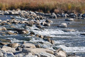
Salt Creek, looking south from the northern edge of Busse Woods Forest Preserve (M. Bryson)
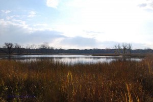
Busse Woods is home to a couple of significant water features including Salt Creek, which was the first stop on our trip. After hiking through a forest-and-wetland path along the northern border of the woods, we came to the Golf Road overpass of Salt Creek, where the river south into the preserve before it empties into Busse Lake, a sprawling artificial reservoir created by a dam structure at the south end of the preserve. Using a couple of different water quality field testing kits, we sampled the creek and measured a range of physical/chemical water quality indicators: chlorine, copper, dissolved oxygen, hardness, iron, nitrate, pH (acidity), phosphate, temperature, turbidity, and total coliform bacteria. In doing so, we not only took the ecological pulse of Salt Creek at one point in time, we also learned how to use our sampling equipment, compared test results from different measurement procedures, assessed the possible sources of error in our data collection, and analyzed the impact of the surrounding landscape upon the water quality of Salt Creek.
The entire Busse Woods preserve is a significant green space within the Salt Creek Upper Watershed, as it receives stormwater run-off from the eastern half of Schaumburg via the main channel of Salt Creek as well as the Creek’s West Branch. That tributary is important for another reason, as it flows through the heart of Schaumburg before passing around the periphery of the John Egan Wastewater Treatment plant of the Metropolitan Water Reclamation District.
Satellite view of Schaumburg's east side, showing the West Branch of Salt Creek and the John Egan Treatment Plant at lower right (Google Earth)
The Egan plant’s treated effluent is piped into the West Branch, which then flows east under I-290 to empty into the South Pool of Busse Reservoir. Partly for that reason, we chose to sample water from the shoreline of the South Pool as our second sampling site of the day. (Interestingly, the data from that site were quite comparable to those we gathered much farther north at Salt Creek.)
In this sense, then, Busse Lake is a giant detention pond for stormwater run-off from several suburban communities (either directly or via Salt Creek) and treated wastewater from Schaumburg. As such, it is a flood control structure for Salt Creek, which runs south/southeast out of the preserve and drains several western suburban communities before joining the Des Plaines River near Brookfield.
The south pool of Busse Lake (M. Bryson)
Effective water retention in Busse Lake means reduced flooding in downstream communities, though the persistence of flooding in the western suburbs means the reservoir as currently configured is only a partial solution. Nevertheless, the larger forest preserve complex of wetlands, prairies, and woodlands — of which the lake is but a part — act like a giant sponge for the surrounding towns and villages, absorbing precipitation and run-off from a wide area and releasing it slowly to the atmosphere and to Salt Creek.
Map of Salt Creek's watershed (Salt Creek Watershed Network)