The Friends of the Forest Preserves have conservation crew leader positions that are available this summer. See this link for details!

The Friends of the Forest Preserves have conservation crew leader positions that are available this summer. See this link for details!
Today, April 27th, is officially my favorite day of the semester: Symposium Day! Please join me at today’s Sustainability Studies Program at Roosevelt University for a special afternoon Symposium of student projects and research from 2:30-5:30pm in RU’s LEED Gold-certified Wabash Building at 425 S. Wabash Ave. in downtown Chicago (room 1214).
Students in Roosevelt’s SUST program will give presentations about their recent campus sustainability projects, internships, and research experiences in a forum that is open to all RU students, faculty, and staff as well as the general public. The Symposium also will be videoconferenced via Zoom, so you may attend online or by phone, if you wish (see below).
I’m exceedingly proud of all of these students and the work they’ve done this semester. Break a leg, everyone!
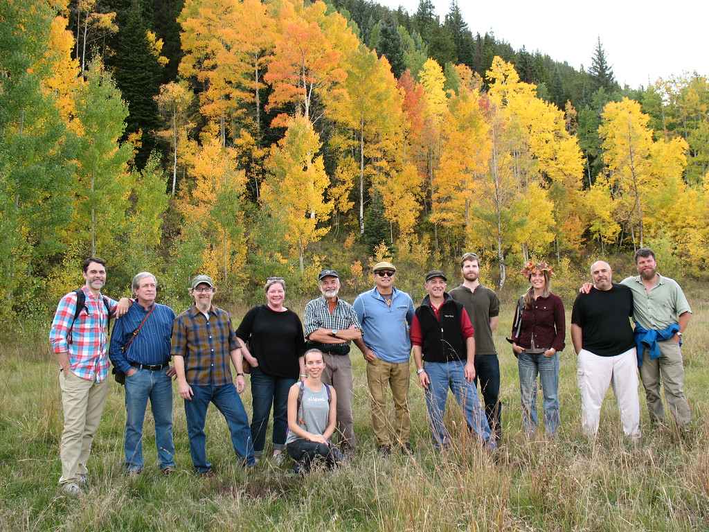
 Members of SUST 390 Sustainable Campus (honors) — From Plan to Action: Moving Sustainability Forward at RU
Students in the Spring 2016 honors seminar “Sustainable Campus” will start our Symposium with a series of group presentations on their campus sustainability projects undertaken this spring to help advance RU’s Strategic Sustainability Plan across several fronts. Teams will discuss their initiatives in four areas: general education curriculum (Nicole Kasper & Kurt Witteman), food waste reduction (Michael Gobbel & Tom Smith), student orientation (Jessica Heinz, Claudia Remy, & Moses Viveros), and bottled water policy (Ashley Nesseler, Lacy Reyna, & Brandon Rohlwing). And if you think they look happy in this photo, wait until they’re done presenting today.
 Lindsey Sharp — A Key to Unlocking Species Diversity at Lolldaiga Ranch
Lindsey is a senior SUST major and returning adult student who was awarded the prestigious Travis Foundation Scholarship this fall at RU, a competitive award given to 16 students each year. The scholarship enabled her to continue her studies as well as pursue a Spring 2016 internship at the Field Museum of Natural History, which she reported on recently here. Her project focuses on the preparation and identification process of specimens collected during field research in the Eastern Province of Kenya. The results of the identification process were also analyzed in order to determine the area’s population of rodent species, which can be compared to earlier samples gathered from the area in order to determine changes in biodiversity over time. Her talk will discuss her everyday work at the lab in the larger context of mammal ecology, biodiversity conservation, and the value of museum collections research.
 Cassidy Avent — Summer at SCARCE: An Environmental Education Internship Experience
Throughout the summer of 2015, SUST senior Cassidy Avent had the opportunity to work as an intern for an environmental NGO known as School and Community Assistance for Recycling and Composting Education (SCARCE). Her summer included working at the SCARCE office in Glen Ellyn IL, giving environmental education presentations at schools and community events, participating in teacher workshops, and many other fulfilling activities. Within this presentation she discusses her experience at SCARCE along with all of the valuable information and insights she gathered while interning at such a fascinating place.
 Tiffany Mucci — Midewin: One Land’s Story of Recovery and Renewal
SUST senior and returning adult student Tiffany Mucci, who has served as the Assistant Editor of the SUST at RU Blog this academic year, explores Midewin National Tallgrass Prairie as a living example of both the challenges we face in restoring and managing our native landscapes, and the resiliency of nature. Her presentation will highlight this site’s history as one of our nation’s most productive ordnance complexes to ever exist, and reveal its present-day designation as a protected tallgrass prairie ecosystem under the U.S. Forest Service. From seeding, to frogging, to corralling the newly-adopted buffalo of Midewin, she’ll relate what goes into “making a prairie” in the 21st century.
 Lacy Reyna — Temporal Distribution of Bryophytes in Cook County, IL
Senior science major and honors student Lacy Reyna, a double major in biology and psychology and RU’s 2015 Lincoln Laureate, worked in the botany division of the Field Museum while enrolled in the museum-based SUST 330 Biodiversity course this past fall with Lindsey. Using collections data from various institutions including the Field Museum, her research done in collaboration with FMNH scientists documents the shift in bryophyte species in Cook County across time. Her talk provides potential explanations for the shifts in species populations as well as discusses the importance of museum collections for biodiversity conservation.
Come join us to learn about and celebrate these students’ work! This event is free and refreshments are provided. Kindly RSVP to Mike Bryson (mbryson@roosevelt.edu) your plans to attend. Videoconferencing will be made available via Zoom. Hope to see you there! And if you need further incentive to attend, just check out past Symposia from 2013-15.
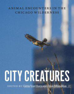 Tomorrow afternoon my SUST 340 Policy, Law, & Ethics class at Roosevelt University’s Chicago Campus proudly hosts a special presentation entitled “City Creatures: Urban Biodiversity in Chicago” at 3:30 p.m. in Roosevelt’s LEED-Gold Wabash Building, Room 1214. Dr. Gavin Van Horn of the Center for Humans and Nature will discuss his recent book, City Creatures: Animal Encounters in the Chicago Wilderness (University of Chicago Press), published in November 2015; and then engage in dialogue with my students and the RU community about urban biodiversity from the perspective of the environmental humanities.
 Dr. Van Horn is the co-editor of City Creatures and is the Director of Cultures of Conservation at the Center for Humans and Nature, as well as editor of the widely-read City Creatures blog. His work focuses particularly on how place-based values are developed and strengthened in dialogue with local landscapes. He continues to explore cultural perceptions of wildlife; place-based ethics; endangered species recovery, ethics, and policy; and the values involved in ecological restoration projects, community gardening, and wildlife management.
This special event is free and open to the public, and is hosted by students in SUST 340 Policy, Law, & Ethics. A limited number of signed copies will be available for purchase ($30 cash) and discount order forms will be available.
Videoconference Option: For those who cannot attend in person, the City Creatures event will be video- and teleconferenced live via Zoom as well as recorded, so that you may watch and/or listen from anywhere in the world. Login information is here:
More on City Creatures from The University of Chicago Press website:
We usually think of cities as the domain of humans—but we are just one of thousands of species that call the urban landscape home. Chicago residents knowingly move among familiar creatures like squirrels, pigeons, and dogs, but might be surprised to learn about all the leafhoppers and water bears, black-crowned night herons and bison, beavers and massasauga rattlesnakes that are living alongside them. City Creatures introduces readers to an astonishing diversity of urban wildlife with a unique and accessible mix of essays, poetry, paintings, and photographs.
 The contributors bring a story-based approach to this urban safari, taking readers on birding expeditions to the Magic Hedge at Montrose Harbor on the North Side, canoe trips down the South Fork of the Chicago River (better known as Bubbly Creek), and insect-collecting forays or restoration work days in the suburban forest preserves.
The book is organized into six sections, each highlighting one type of place in which people might encounter animals in the city and suburbs. For example, schoolyard chickens and warrior wasps populate “Backyard Diversity,” live giraffes loom at the zoo and taxidermy-in-progress pheasants fascinate museum-goers in “Animals on Display,” and a chorus of deep-freeze frogs awaits in “Water Worlds.”
 Although the book is rooted in Chicago’s landscape, nature lovers from cities around the globe will find a wealth of urban animal encounters that will open their senses to a new world that has been there all along. Its powerful combination of insightful narratives, numinous poetry, and full-color art throughout will help readers see the city—and the creatures who share it with us—in an entirely new light.
This past September, I joined a group of writers convened by Gavin Van Horn (of the Center for Humans and Nature in Chicago) and John Hausdoerffer (a professor at Western State Colorado University and the director of WSCU’s Headwaters Project) for a much-anticipated writers’ retreat in the beautiful mountain town of Crested Butte, CO. The idea was to gather invited writers together to shares conversation, ideas, outlines, and initial jottings as a means of kicking off a new book project to be co-edited by Gavin and John called The Relative Wild. As they describe it, this is a collection of stories and essays that
will explore how human and ecological communities co-create the wild. The “myth of the pristine” — that nature is most valuable when liberated from human presence — is quickly being supplanted by “the myth of the humanized,” the assertion that nothing is untouched by human influence, and therefore one may embrace ecosystem change, even extreme changes, as “natural.” We suggest that both of these myths deserve equal scrutiny, and that one way to do so is by celebrating the common ground of the relative wild: the degrees and integration of wildness and human influence in any place.

Having participated in a previous CHN writer’s retreat at the Indiana Dunes National Lakeshore for the forthcoming book City Creatures (Univ. of Chicago Press, 2015), I know firsthand how extraordinary an opportunity it is to take time out from the busy schedule and harried demands of ordinary life to mingle with talented and creative writers all focused on a common project. The fact that the Relative Wild gathering transpired in a beautiful mountain setting at the autumnal equinox was even better. Over the course of two and a half days, we had many great conversations, took hikes in the stunning mountains and valleys outside of Crested Butte, ate meals together, used quiet time for writing and reflection, and engaged in several productive and inspiring writing workshop sessions led by the esteemed naturalist and prolific nature writer, Robert Michael Pyle.
My planned contribution to the book will be co-written with Mr. Michael Howard, the Executive Director and founder of Eden Place Nature Center in Chicago, and is tentatively entitled “Cultivating the Wild on Chicago’s South Side: Stories of People and Nature at Eden Place.” What follows below is an example of the writing we were assigned to do at writers’ workshop. Here, Bob Pyle challenged us to closely observe and meditate on our immediate surroundings and experiences in Crested Butte that weekend, and to write about them as evocatively as possible. Whether or not we connected these observations to our planned essay/story topics for the book was optional. His writing prompt — to start with the phrase, “Encounter, here . . .” — was both deceptively simple and (for me) highly challenging. This is what I wrote.
Three Encounters (in response to Bob Pyle’s writing prompt)
by Mike Bryson
Encounter: Crest Butte, CO
September 21 — We leave our lodge on foot here in town, walk for what only seems to be a few blocks (hardly far enough to go anywhere at home), and suddenly, we’re on a mountain trail. We hike high above the winding Slate River, through intermittent stands of turning-gold aspen. I gawp at the massive bulk of Mount Crested Butte, Gothic Mountain, the interplay of rock and tree line, the contrasting beauty of the valley, the rich topography that is overwhelming in its newness and scale.
The damp, rich, loamy smell of the forest, though, makes just as strong an impression. Aspen leaves are scattered on the trail, gold, green-dappled, as beautiful as mountains. My companions, old friends and new, chuckle at my boyish “golly gee” reaction to this place. I am a rube in this wilderness, as stupefied as a farm boy in New York City.
September 22 — After dark, I gather six aspen leaves of varying size and hue, each jeweled with perfect drops of rainwater. I blot them dry in my room, press them between the pages of Gary Snyder’s Mountains and Rivers without End. It’s comforting to know that my wife and children will consider this a worthy gift upon my return.
Encounter: Metamora, IL
Reeser family reunion at the Mennonite Heritage Center, east of Metamora in central Illinois’ Woodford County. The heart of Illinois farm country, just northeast of Peoria, soils built by centuries of deep-rooted prairie growth, decay, regeneration. Corn and soybeans now dominate this quiet land, the rolling soft green hills of the Mackinaw River valley belying the fact that this is in part a built environment, made and maintained with tractors and chemicals. The ditches and streams here are as vulnerable to nitrogen runoff from the seasonal applications of anhydrous as Oh-Be-Joyful Creek is to heavy metal contamination from the Daisy Mine upstream of Crested Butte, Colorado.
After our family’s potluck dinner and visiting with elderly relatives over rhubarb pie and weak coffee, we walk over to a half-acre prairie restoration dedicated to my great-great-great grandfather, Christian Reeser, a Swiss-German immigrant who lived and farmed to age 104. Once much of Illinois looked like this. Tallgrass prairie: 1/100th of one percent remains.
Encounter: Chicago IL
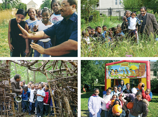
September 17 — Eden Place Nature Center, in the Fuller Park neighborhood on Chicago’s South Side. Michael Howard and I sit and talk in the trailer that serves as office, classroom, conference area, and tool shed at Eden Place, a 3.4-acre farm and nature center wrought from the desecration of an illegal waste dump in the middle of a residential area in one of Chicago’s poorest, smallest, most isolated, and most polluted neighborhoods. Outside, goats bleat, chickens fuss and cluck, two ponies graze quietly.

The early stages of an oak savannah and prairie restoration take up the north half of this refuge, the only bona fide nature center on the entire south side of the city. Modestly sized and brightly painted barns stand against the tall concrete embankment of the railroad that runs along Eden Place’s western border. Exhaust-streaked trains, passenger and freight, clatter by at short intervals. Too often, freight lines stop and idle here, engines rumbling, diesel fumes thick in the air. Raised-bed gardens sport squash, beans, peppers, tomatoes, herbs.
“What is this book supposed to be about again?” Michael asks. “Remind me. I’m sorry — this has been a long week.” He is exhausted by his new job at the Illinois Department of Natural Resources, but relieved to have stolen a few rare moments of down time at Eden Place. An oasis in the city.
“The Relative Wild,” I reply. He nods, looks thoughtful.
“When we created Eden Place,” he said, “the thought was this: if we build it, the wild will come.” And so it has over the last fifteen or so years. Red-tailed hawks. Migrating songbirds. Raccoon, opossum, skunk. White-tailed deer, seen in the damp mist at two in the morning. Urban wild amidst an imposing hardscape of pavement and gravel, humble houses and gritty vacant lots, cut off and bounded by physical barriers of twelve-lane expressway, railroads, abandoned industrial yards. Build it, the man says. The wild will come.
Crested Butte, CO
September 23, 2014
This coming fall semester (2015) I will be offering a transformational service learning course, SUST 350 Service and Sustainability, at the Chicago Campus. Our course theme is Urban Farming, Environmental Education, Community Development, & Social Justice.
SUST majors and minors may take this class to fulfill an upper-level SUST requirement, but 350 also is open to students at large who need a general education course or desire elective credit.
Introduction to the Course
SUST 350 focuses on one of sustainability’s “Three Es” — social Equity — within the broad context of Environmental stewardship and Economic development. Students will learn about one of the most important components of sustainability — food production and consumption — in the context of urban neighborhoods and ecosystems.
By doing hands-in-the-dirt labor at Eden Place Nature Center on the city’s South Side neighborhood of Fuller Park, students will gain direct knowledge of contemporary organic/urban agricultural systems as well as learn about pressing urban social justice issues such as food deserts, gentrification, pollution, environmental racism, and persistent poverty. The initial class meeting will be at RU’s Chicago Campus, and subsequent class meetings will take place at Eden Place Nature Center.
An urban farm is about food, but so much more besides. The Fuller Park community is an economically stressed neighborhood that is bisected by the Dan Ryan expressway and bounded by railroads on its eastern and western borders. Here, an urban farm and community nature center is a source of freshly grown, organic produce; a training ground for local youth in need of practical job skills; a stop valve in the Cradle-to-Prison pipeline; a gathering place for people of all ages in the community for physical exercise, informal education, and social events; a demonstration site for sustainable agricultural and ecological restoration techniques; a model of economic development on a local, sustainable scale; and a means of reconnecting urban folk to the natural world. More generally, in urban areas starved for jobs, green space, safe outdoor gathering places, and fresh quality food, enterprises like Eden Place productively and powerfully address the need for social equity and progressive change.
Our main focus will be on helping with various urban agriculture and environmental restoration projects at Eden Place Nature Center at 4417 S. Stewart, as well as at the Eden Place Farm at 4911 S. Shields. Our typical day will consist of meeting at the WB Lobby ~11:30am to take the Red Line to EPNC (students have the option of commuting there directly to meet at noon); convening at 12pm for discussion of assigned readings and, later in the semester, informal student presentations; and then working with Eden Place staff on various environmental, farm, and/or public education projects according to the needs and schedule of Eden Place.

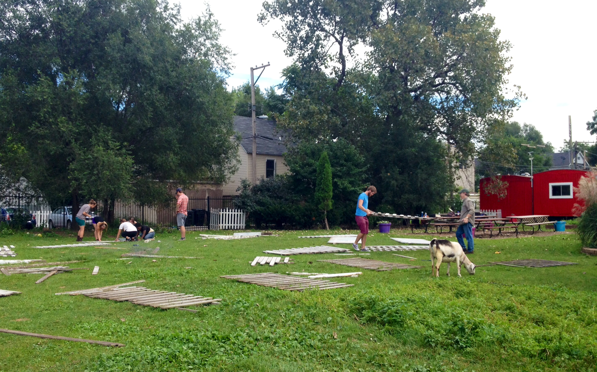
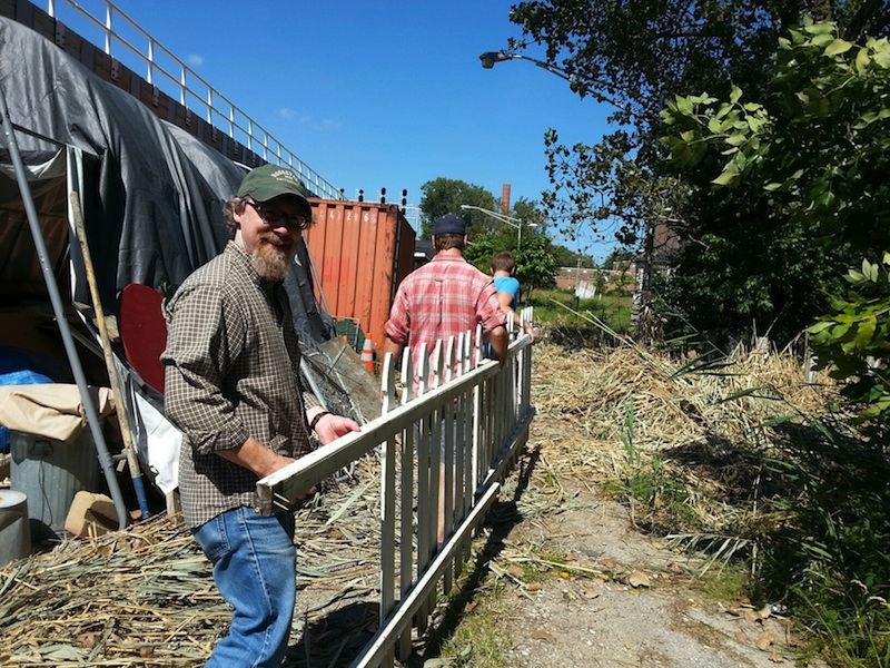
The vast majority of our work takes place outside, regardless of weather. We built trails, planted trees, pulled weeks, raked leaves, managed compost piles, helped set up activities and structures for Octoberfest, repaired and installed fences, and many other chores/activities. We also interacted with EPNC staff to learn about their mission and vision for the future. Last but not least, we always had a little time each week to visit with EPNC’s many animals, including Gaga the goat (who loved to intervene during our roundtable discussions in the gazebo!).
Partner Organization: Eden Place Nature Center
From the Eden Place website:
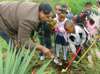
“In 1997, community member, founder, and Executive Director of Fuller Park Community Development Michael Howard [pictured at left] was concerned about the serious lead poisoning problems affecting the neighborhood children. Through research he discovered that Fuller Park contained the highest lead levels in the city of Chicago. As a community leader he wanted to make some serious changes for the sake of his family and his entire neighborhood, and he decided that this work would start with the illegal dumpsite located across the street from his home.
“Mounds of waste over two stories tall encompassed the entire three acres of land. Mr. Howard acquired the deed for the land and involved the community in a large scale, three year clean-up of the dumpsite. Alongside his wife and fellow activist Amelia, and in partnership with hundreds of volunteers and community members, Mr. Howard led a clean-up project in which more than 200 tons of waste including concrete, wood, tires and other toxin-laced materials were removed from the site.
“Upon clean-up of the site, the next step was development. Tons of fresh soil were brought in to establish the Great Lawn, and the Hope Mound was established as the first permanent fixture on Eden Place. South Point Academy trainees contributed a number of early structures to the Eden Place grounds, including the gazebo, DuSable Trading Post, and the storage sheds. The Mighty Oak and other surrounding trees formed the woodland at the north end of the property, including a reflecting pond meant to encourage reflection and respite from the urban surroundings.
“In May of 2004, Eden Place was honored by the U.S. Environmental Protection Agency and Chicago Wilderness with The Conservation and Native Landscaping Award. The winners were recognized for their extensive and creative use of natural landscaping to support native plants and animals that contribute to the region’s biodiversity. That same month, Eden Place was filmed for a PBS special documentary called Edens Lost & Found. This documentary profiles activists and organizations in Los Angeles, Seattle, Philadelphia, and Chicago who are attempting to ‘improve the quality of life and public health by encouraging community and civic engagement through the restoration of their urban ecosystems.’
“Eden Place has continued to develop and grow with the support and recognition of local leaders and organizations. We have worked to raise awareness amongst community members about the environmental problems that have affected their families for years. Local residents are making connections with nature like never before, and they are feeling a sense of community pride like never before. However, our work in the community is not finished. More than 3/5 of the local area is comprised of abandoned lots where homes and various industries once thrived, and Fuller Park residents still carry the burden of one of the highest local lead contents in the city. Through our partnership with local and national conservation organizations such as the Chicago Zoological Society, the Audubon Society, the U.S. Forest Service International Programs, Chicago Wilderness, Openlands, and NeighborSpace, we will continue to establish green community space and education that will improve the health and well-being of our community.”
For more information on this unique service learning course, please contact Prof. Mike Bryson (mbryson@roosevelt.edu or 312-281-3148).
 Yesterday I arrived at the University of Notre Dame in South Bend, Indiana — my first visit to this storied campus — to participate in the annual meeting of the Society for Literature, Science, and the Arts. This year the conference theme is “Postnatural.”
My talk yesterday afternoon was part of a panel entitled “Water and the City,” and included stimulating presentations by Christine Skolnik of DePaul University (“Imagined Eco-Futures” Restoring the Current” [of the LA River]) and Peter Hobbs of York University in Toronto (“What Does Lead Do? Toxic Entanglements, Exposures, and Cosmo-Chemo-Politics”).
Below is the introduction to my talk, which was an extemporaneous exposition of this slideshow (pdf, 10MB file).
Water and the Postnatural City: Reversals, Invasions, and Prospects for Sustainability
It is hard to think of a natural substance more vital to life than water. Yet, “the natural” is difficult to locate amidst the bewildering complex of intakes, filters, screens, pumps, chemical treatment chambers, distribution mains, pipes of all sizes, gutters, storm drains, sinks, sewers, settling tanks, combined sewage overflows, canals, locks, oxygenating waterfalls, electric fish barriers, and myriad other technological accouterments that allow us to convey, control, imbibe, and dispense with freshwater/wastewater in our cities and suburbs.
Despite the utter domination of water’s movement by what environmental engineers call the “hard path” of water resource management, however, the capacity of even highly degraded urban river corridors to support surprising levels of biodiversity — not to mention the tendency of urbanized landscapes to flood — demonstrates that Nature in the form of wild (read: violent) water frequently reasserts its power over us.
This presentation takes a deep dive into the water resources and management systems of the Chicago Region to ask:
Question: What do the northeastern Illinois communities of Arlington Heights, Batavia, Chicago, Downers Grove, Evanston, Hoffman Estates, Naperville, Northbrook, Oak Park, Plainfield, and St. Charles have in common with Cincinnati, OH; Nashville, TN; Pittsburgh, PA; Sioux City, IA; and Topeka, KS?
Answer: All of them allow city residents to keep backyard chickens for egg production.
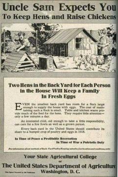 Here in Joliet, there’s a grassroots movement aflutter to legalize residential chicken-keeping, a plucky proposal I enthusiastically support.
The virtues of city and suburban backyard hens are many and various. As noted by the local advocacy organization J-Hens (Joliet Healthy Eggs in Neighborhoods), urban chickens:
To be sure, uninformed naysayers wrongly assume that backyard chickens are dirty, noisy, and detrimental to local property values. I do know many so-called humans who fit such a description, and I bet you do, too. But not our dirt-scratching, bug-eating feathered friends. (Yes, folks — chickens love to eat bugs. What’s not to like about that?)
Let’s start with the property value myth. First of all, the irresponsible wrongdoings of many American financial institutions have wreaked exponentially more havoc upon the local housing economy the last five years than anything a few little hens down the alley could ever do.
 Secondly, just look again at the list of cities above: does anyone really believe that the affluent communities of Arlington Heights, Evanston, Naperville, and the regulation-obsessed Oak Park — all cities with far higher average home values than Joliet — would’ve approved their backyard hen ordinances if property values were truly at risk? I rest my case.
What about the chicken poop? you ask. Won’t it be stinky? Of course it will — IF YOU DON’T CLEAN IT UP. Again, let’s get real. Our present-day urban landscape is constantly bombarded with doggy doo-doo from the tens of thousands of dogs slobbering along in our midst and treating our lawns and parkways as their personal bathrooms. These putrescent pooch piles are large, stinky, and messy — I know because I’ve cleaned a lot of them up in my 45 years. But do we outlaw the keeping of dogs as household/backyard pets because of their daily defecations? No — we simply expect their owners to deal with the waste properly.
And as for alleged noise problems: we’re not talking roosters here. Hens are quiet and unaggressive compared to those preening and caterwauling males of the species, not to mention yappy canines and loudmouth people. (You know who you are.)
If Joliet really wants to deal with urban noise issues, I suggest the Council turn its attention to the bass-thumping car stereos that rattle my teeth and jiggle my liver as I sit in my vehicle waiting for the stoplight to change. How about an ordinance against those aural abominations?
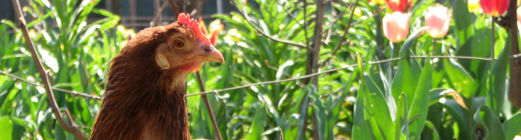
![]() More backyard chickens. Less liver-jiggling noise pollution. Now that would be progress!
More backyard chickens. Less liver-jiggling noise pollution. Now that would be progress!
I encourage all forms of urban gardening and farming, especially in my hometown, and recommend the J-Hens website to readers near and far. I also love doggies and my fellow man, contrary to what this article might imply. A version of this essay appears in the 5 June 2013 edition of the Joliet Herald-News as the creatively-titled “Backyard Chickens in Joliet.”
From my perch this morning at the Joliet Public Library’s West Branch, I’m looking out at the Rock Run Forest Preserve of Will County, which is adjacent to the library. Looks like folks from the FPDWC are doing a prescribed burn today in the preserve’s woodland that borders the big marsh.
A good view as I work on my biodiversity online discussion forum for my Sustainable Future class!

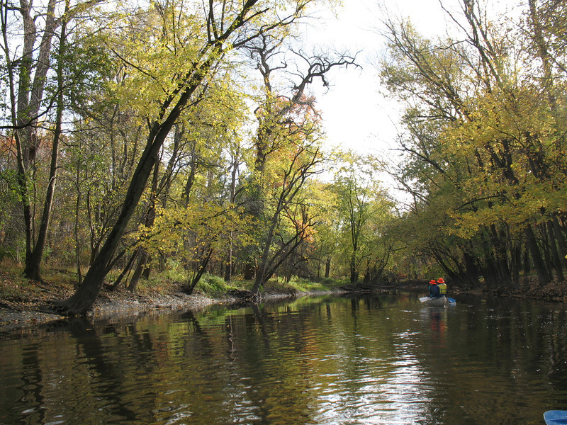
Last Saturday, Feb. 23, my SUST 220 Water students (both past and present) joined me at a wonderful annual event here in the Windy City: the Chicago River Student Congress, convened by the environmental conservation organization Friends of the Chicago River. This 2013 celebration of river conservation and environmental education was held at Marie Curie Metro High School on Chicago’s SW Side, and featured yours truly as the “special guest speaker,” a designation that made me proud and humble at the same time, for I still consider myself a student of rather than an expert about the Chicago River.
The Chicago River: Transformed, Exploited, and Abused — but Still Alive
Chicago River Student Congress Special Guest Presentation (pdf version)

Last year, I co-presented a workshop session on Water and Sustainability with then-SUST major (and now alum) Amanda Zeigler (BPS ’12); you can view a pdf of our slideshow from that 2012 workshop. This successful experience led me to recruit three students from my Fall 2012 Water class at Roosevelt to be fellow participants in this year’s Congress. The fact that my Fall and Spring Water classes this academic year are partnering with Friends of the Chicago River on a “Blueways to Green” environmental education grant made that prospect irresistible.
Former canoeing partners and classmates, Ron Taylor and Ken Schmidt — whose collective nickname “Ebony and Ivory” demonstrates the awesome power of the river to bring together people of all races, creeds, and colors — agreed to co-present a workshop with me entitled “Sustainability and the Chicago River: from Urbanization to Pollution to Restoration,” which we did twice during the course of the Congress (here’s the pdf of our slideshow (8MB file). Ron and Ken skillfully shifted back and forth in their presentation, and were able to elicit lots of dialogue from their audience member, mainly students from CPS high schools who have done environmental conservation and/or science projects on the river.
Meanwhile, roaming the halls of the Congress was fellow SUST major Angi Cornelius, another student from my Fall 2012 Water class, who indulged her theatrical side by dressing up as one of six “Super Villians” who represented ecological/social threats to the biodiversity and water quality of urban rivers. Angi’s character was “Z. Mussel” (the zebra mussel, naturally), an invasive bivalve species that she refashioned into the persona of a Russian femme fatale. Along with her fellow Villians, Angi worked the crowd throughout the morning by engaging students in small group conversations about the impact of invasive species on rivers, streams, and the Great Lakes ecosystem.
Students from my current section of SUST 220 Water met at the Congress for our 4th week of class and our 2nd field session of the semester. The Congress is a unique learning opportunity, as it features a wide variety of speakers and workshops — some by high school teachers and students; some by college profs and students; and a few by conservationists, environmental professionals, etc. — that provide attendees with science-based knowledge about the river’s history, ecology, present status, and future prospects.
For photos of the Congress, check out my annotated slideshow as well as this online album from the Friends of the Chicago River’s Facebook page.
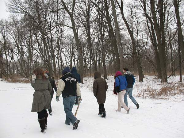
Following the Congress and a quick sack lunch at the high school, during which we bade farewell to Ron, Ken, and Angi, my 220 scholars and I carpooled to a nearby Cook County Forest Preserve location that has profound historical and geographic significance to the city of Chicago, the Chicago and Des Plaines Rivers, and two of the great North American watersheds (those of the Great Lakes and the Mississippi River). This is the Chicago Portage National Historic Site at 4800 S. Harlem Ave. in Lyons, one of only two National Historic Sites in the entire State of Illinois.
If the Metropolitan Water Reclamation District’s Stickney wastewater treatment plant just to the east is a supreme example of how we use technology and the built environment to control water as a resource (and deal with the problem of wastewater), the Chicago Portage is polar opposite kind of experience. Here we see the landscape much as it appeared to the 17th century explorers Louis Joliet and Pierre Marquette, when they crossed Mud Lake (now occupied by the Stickney WTP) between the Des Plaines and Chicago Rivers, thus staking out a trade route between the Great Lakes and the Gulf of Mexico.

Our last stop of the day was further east on Interstate 55, where we exited north on Ashland Avenue and stopped at Canal Origins Park. This riverside parkland (and fishing spot) provides impressive views of the present-day juncture of the Chicago River’s South Branch and Bubbly Creek, and commemorates the origin of the historic I&M Canal, which was constructed from 1836 to 1848 and fulfilled Joliet’s dream of connecting the Great Lakes with the Mississippi River system. Here, then, is a superb spot to talk about the history, ecology, and geography of the creeks and rivers which run through the city, as well as the industrial and wastewater treatment processes that have polluted these waters over the years.
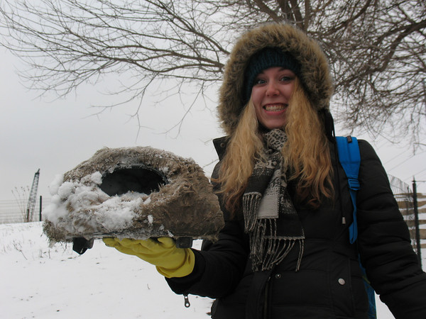
At Canal Origins, we engaged in some good old-fashioned service learning, Roosevelt-style, by donning work gloves and picking up any litter/recyclables we came across. A recent blanket of snow concealed most of the litter in the upper part of the park, along the busy street. But down at the river line at the South Turning basin, where Bubbly Creek enters into the South Branch, lots of garbage and urban detritus presented itself for our labors.
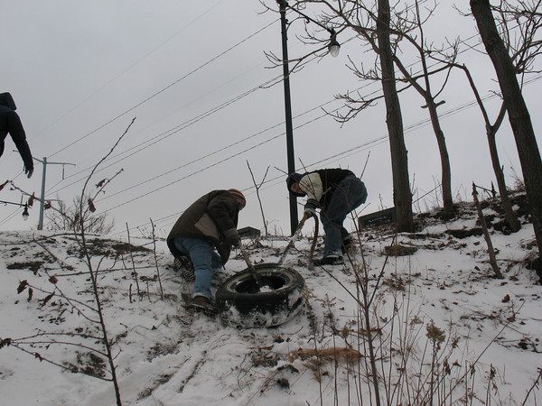
My students hurled themselves into this effort with purpose and enthusiasm, not the least impressive for coming at the end of a rather long day to that point. All manner of intriguing (and sometime revolting) artifacts were retrieved, from beer cans to paper cups to plastic bags to old clothes and towels to large pieces of ships’ rope to automobile tires to tampons to (most bizarre) fur-covered rat traps with wheels.
Here’s an annotated slideshow of photos from the day of our visit to Chicago Portage and Canal Origins.
After heroically hauling a heavy, ice-filled tire out of the river and up a steep slope, using one of the old ships’ ropes as a winch line, Conor and Chris suggested that the SUST program at RU should adopt the Canal Origins Shoreline as a parkland, and clean up litter there on a regular basis.
Doesn’t sound like a bad idea to me.
Today I head west to the city of Rock Island, which hugs the Mississippi River in northwestern Illinois (right across the water from Davenport, Iowa). I’ve been invited to give a talk on urban sustainability issues in Chicago at Augustana College’s annual Winter Symposium, which this year is focused on sustainability and environmental issues. Since I can never resist a chance to talk about urban waterways, my talk is entitled “Paddling the Chicago River: A Good Way to Think about Science, Art, Ethics, and the Sustainability of Cities.”
The degraded yet undeniably charismatic Chicago River is a mighty fine place to contemplate the tangled relationships among water quality, land use, and sustainability within cities and suburbs. As a site for exploring urban nature, an object of analysis in the scientific assessment of water quality and urban ecology, and a case-study in landscape aesthetics, the Chicago river provides students and citizens myriad opportunities to develop a sense of place. More generally, experiencing urban rivers — and understanding their function within the complex watersheds of metropolitan regions — can foster not just ecological literacy about urban ecosystems but also ethical engagement with one’s community.
Here’s a pdf version of my presentation.