Summer Internships: Sustainability in Chicago’s Communities

This semester my SUST 210 honors class is working on a community-based research project in collaboration with the Chicago non-profit organization, The Institute for Cultural Affairs, based in Uptown. Along with students from several other Chicago colleges and universities, we are researching and mapping sustainability initiatives throughout each of the city’s 77 community areas. The work continues this summer, so the ICA is seeking motivated and interested students for 40 unpaid internships on this tremendous and valuable city-wide project. Here are the details! — Mike Bryson

Application deadline now extended to Monday, April 16, 2012

The ICA Summer Internship Program, “Accelerate 77” is an opportunity for undergrad and graduate students to participate in preparations for the September 15, 2012 Share Fair event that will highlight, connect and accelerate local sustainability initiatives at the community level throughout Chicago neighborhoods. During the 2011-2012 academic school year, 180 students from six Chicago-based universities have participated in the first phase of the Accelerate 77 project by doing fieldwork in 54 of the 77 Chicago community areas. This summer, students will have the opportunity to take the Accelerate 77 project to the next level developing their skill-set through hands-on community based projects and acquiring skill in facilitation and enabling participatory group processes.

This spring ICA will be interviewing for 40 intern positions – flexing the program timetable between June and August.  The positions range from:

*  community documentation and engagement of sustainable initiatives,
*  designing and planning the September 15th event celebrating the 231 initiatives (three initiatives from each of the 77 communities),
*  marketing and public relations for the Accelerate 77 project and share fair event, and
*  website support for the community documentation, interchange and post-event collaboration.

Out of the 40 intern positions, the program will offer eight students an intensive leadership development course that will provide hands-on experience of co-leading teams in collaboration with eight ICA resource guides.

More information on leadership development opportunities and the Accelerate 77 project can be found at this page on the ICA website.

Application deadline: Monday, April 9, 2012

For more information, check out these documents:

Nina Winn
ICA Program Coordinator
nwinn@ica-usa.org
Office:  773.769.6363, ext 301

Karen Snyder
ICA Volunteer and RU alum
snyder@consultmillennia.com
Home office: 773.506.2551
Cell: 773.758.2551

A Good Week for Chicago

Environmental news is rarely good. More often it’s disconcerting . . . depressing . . . or highly disturbing. This week, it’s a breath of fresh air (literally) to get some phenomenal news about the near-future prospects for air and water resources here in Chicago.

As Michael Hawthorne, environmental reporter for the Chicago Tribune, writes this week, the notorious and heavily-polluting Fisk and Crawford coal-powered generating stations will be shut down earlier than projected by their owner, Midwest Generation. While the economic infeasibility of upgrading the plant’s pollution controls is the direct reason, there is no doubt that continued pressure from local environmental activists in the Little Village and Pilsen neighborhoods as well as from key Chicago politicians (including Joe Moore of the 49th ward and Mayor Emanuel) were key drivers in this decision.

As if that weren’t cause enough for joy, we also learn today that the Metropolitan Water Reclamation District has significantly reduced the projected expense of implementing final-stage disinfection processes for wastewater effluent that is released into the Chicago Area Waterway System. Installing these technologies will be done in budget rather than with a Cook County tax hike.

Read Hawthorne’s excellent report on what has become a hot water topic in Chicago, and find out why a change of leadership is sometimes all it takes to get things moving in a dramatically different, and positive, direction.

Ryan Hodgson-Rigsbee Publishes Urban Nature #10

My friend and fellow urban nature admirer, Ryan Hodgson-Rigsbee, recently left his home turf of Chicago to live in and explore New Orleans. But Ryan’s still creating amazing work about the City of Big Shoulders. Check out his newest edition of the online ‘zine, Urban Nature (#10). I was glad to provide a bit of introductory text to two of the photo essays therein: “The Blizzard” and “While Wandering: Chicago.”

The photo above is from “The Blizzard,” and depicts the Bloomingdale Trail, a proposed elevated rails-to-trails parkland project on Chicago’s North Side. (I mentioned the trail in this blog essay on urban nature published last year.)

Great Lakes Commission Releases Asian Carp Study

For the last several months, the Great Lakes Commission and the US Army Corps of Engineers have been conducting parallel studies on the feasibility of re-separating the Great Lakes and Mississippi River watersheds here in the Chicago Region. This challenging process is motivated by the threat of Asian Carp moving northward from the Illinois Waterway system through the Chicago and/or Calumet Rivers and into the Great Lakes.

While the Corps’ study is wide-ranging and focused on the Asian Carp threat throughout the Mississippi River and Great Lakes basins — and thus on a much slower timetable, to the frustration of many environmentalists and regional governmental leaders — the Great Lakes Commission has just released its full report, “Restoring the Natural Divide,” to the public. As noted here by the Chicago Tribune’s Andrew Stern and Sandra Maler,

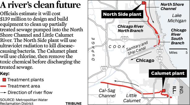
Keeping the invasive Asian carp out of the Great Lakes will involve re-reversing the flow of the Chicago River — an engineering marvel completed a century ago through a complex network of rivers, canals, and locks, a new study said on Tuesday.

The study proposed three options to separate the Great Lakes from the Mississippi River basin near Chicago and keep Asian carp and other invaders out but all three would require re-reversing the flow of Chicago river which now carries Chicago’s treated waste water away from its Lake Michigan drinking water.

“Physically separating the Great Lakes and Mississippi River watersheds is the best long-term solution for preventing the movement of Asian carp and other aquatic invasive species, and our report demonstrates that it can be done,” said Tim Eder, executive director of the Great Lakes Commission, sponsor of the study with several other interest groups.

The prolific Asian carp have populated the Mississippi River and many of its tributaries and now threaten the $7 billion fishery in the lakes, which contain one-fifth of the world’s fresh surface water and supply 35 million people with drinking water.

The invasions by Silver and Bighead carp, first introduced to control algae in commercial fish ponds, have prompted promotional efforts to catch them as a source of cheap protein or for sport fishing, but their populations have exploded.

The U.S. Army Corps of Engineers, which is conducting its own long-term study on possible separation of the watersheds that is due to be completed in 2015, has erected electric underwater barriers at a canal bottleneck near Chicago to try to keep the carp at bay, but some marine experts fear the carp may have already bypassed the barriers.

Several states bordering the lakes have demanded stronger action and have filed a suit against the Army Corps calling for quick action to erect separation barriers and speed up its study.

Michigan Attorney General Bill Schuette, who is pursuing the states’ lawsuit, praised the Commission’s study, saying “with thousands of jobs and a spectacular ecological resource at stake, we can no longer afford to wait for the federal government.”

Commercial shippers and the recreational and tour boat industries have opposed closing locks and dams between the two watersheds, saying it would destroy their businesses. Previous federal court rulings have also noted closing locks permanently would worsen flooding during storms.

Four Indiana congressmen issued statements objecting to the economic cost to the northwest corner of the state if plans are undertaken to permanently divide the two watersheds. . . .

Environmental groups backed the separation plans, with Marc Smith of the National Wildlife Federation saying the study “puts solutions on the table that are both feasible and affordable.”

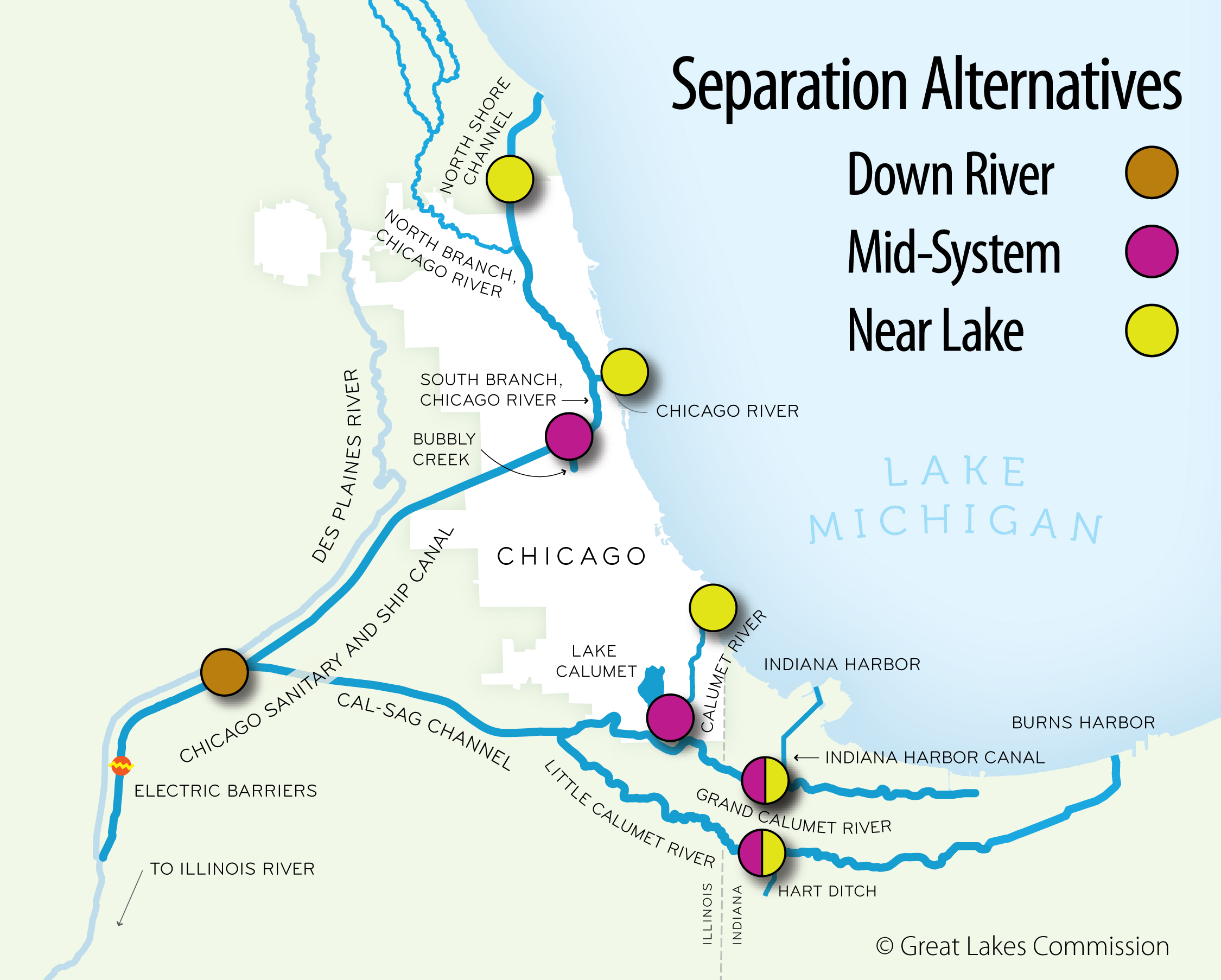
The Commission’s 18-month-long study estimated the total cost of erecting barriers to achieve ecological separation and measures to address water quality, flood prevention and alternative transportation at up to $9.5 billion.

The least costly option, the “Mid System” approach, would cost between $3.3 billion and $4.3 billion and involve erecting four barriers including one near the existing O’Brien Lock nearly Lake Calumet. At that point, a facility could be built to transfer cargo between river barges and trains, trucks, or lake-going boats. A second barrier on the Chicago River could be equipped with a system to lift and transfer recreational boats from one side to the other.

Another option would place five barriers in waterways closer to Lake Michigan, and a third would place one barrier further downstream. Both pose significant transportation and flood management challenges, raising the costs to more than $9.5 billion, the study said.

The study projected a two-phase implementation of the plans with an initial target to erect barriers by 2022. Flood protection depends in part on completion by 2029 of a $3.7 billion system of tunnels and reservoirs designed to divert Chicago area’s stormwater, a project begun in the early 1970s.

Besides Asian carp and its ability to scour the lakes’ food supply and out-compete other fish species, the Army Corps has identified 39 other invasive species — 10 poised to enter the lakes and 29 ready to invade the rivers — that could traverse the two watersheds and threaten the ecological balance. Those include fish such as the northern snakehead, plants such as the water chestnut and mat-forming hydrilla, and crustaceans such as the spiny water flea.

A total of 180 non-native aquatic species are established in the Great Lakes, and 163 are established in the Mississippi River basin.

What will be interesting to see is how the Great Lakes Commission’s report impacts the current dialogue about the best way to proceed in keeping the Asian Carp at bay while simultaneously assuring the economic and environmental sustainability of the Great Lakes-to-the-Gulf of Mexico shipping connection. In the meantime, I recommend the Report’s extensive website, which also features abundant video and image resources.

Internship Opportunity at Alliance for a Greener South Loop

Looking for a cool sustainability-themed internship opportunity here in downtown Chicago? Want to hone your research and writing skills in a professional context, while furthering the progressive goals of a local environmental organization? The Alliance for a Greener South Loop (AGSL), an environmental advocacy non-profit dedicated to improving and encouraging green practices in the South Loop neighborhood of Chicago, is seeking an intern this winter/spring to work on the following:

  • Research/document local resources to support green efforts (e.g., buying electricity in Illinois’s open market)
  • Writing up best practices locally (business, residential, and/or institutional) using input from AGSL award applications and further research as needed
  • Answering questions received by residents, organizations, and companies about green practices such as green roof planning/installation, wind turbines, and composting
  • Generating community engagement through developing online surveys about, for example, green purchasing attitudes and patterns about paper, electricity, etc.
  • Developing ideas to support individual and collective behavioral change and creating a voice to influence local policy decisions related to sustainability

Application Deadline: 1 February 2012

Internship Requirements:

The application process for this internship is competitive, as strong writing, research, time management, and deadline-meeting skills are a must. Knowledge about current environmental issues and sustainability practices (such as those covered in RU’s SUST curriculum) is important, as well. Experience analyzing data and/or developing information for websites is desirable, though not required. Current RU undergraduates may apply; preference is given to Sustainability Studies majors. Applicants should have sophomore standing, at least one SUST course with a grade of B or better, and a minimum cumulative 3.0 GPA.

Workload / Hours / Academic Requirements:

The selected intern will be supervised by Ms. Gail Merritt of the AGSL, with academic support/direction by Professor Mike Bryson in the Sustainability Studies program. The basic work requirement is a minimum of 10 hours per week for twelve weeks (120 hours total) of on-task work at the AGSL, some of which may be completed off-site (depending upon the intern’s school/work schedule). Other requirements include submitting weekly timesheets to the on-site supervisor and faculty instructor; holding 2-3 meetings with the instructor to discuss the progress of the internship; keeping an informal weekly journal of notes and reflections summarizing that week’s work; and submitting a final research paper (7-10pp) that synthesizes reflections on the internship experience within the context of a sustainability issue(s) of particular interest to the student.

This internship is unpaid but may be taken for SUST 350 course credit (Service & Sustainability, 3sh, pre-req ENG 102). SUST majors may use this class as a major requirement, relevant elective, or general elective; non-majors may use it as elective credit. The successful applicant may register for SUST 350 as a “course by arrangement” for the Spring, Summer, or Fall 2012 semesters. Regardless, the internship would begin in early February, 2012.

Application Deadline: 1 February 2012

To apply, send an email application to Professor Mike Bryson (mbryson@roosevelt.edu) that includes the following:

  • Your name, contact information, student ID, RU major, and previously completed SUST courses (semester and grade noted)
  • Personal statement indicating your interest in the internship experience (500 words max)
  • Work availability (days/times), assuming a ten-hour/week commitment with flexible scheduling possible
  • A writing sample of two graded RU essays, with class/instructor/date noted (attached to your email as Word or PDF documents)

For More Information

Contact Mike Bryson (mbryson@roosevelt.edu; 312.281.3148 office; 815.557.3153 cell) and/or check out the Alliance for a Greener South Loop website.

New Book on the Chicago River’s Reversal

The reversal of the Chicago River — one of the great engineering projects of the late 19th century — impacted both the watersheds of the Chicago Region as well as the economy of the city and its suburbs. While that transformation and its consequences have been much discussed, a new photo book significantly adds to that documentation, as discussed by a recent article in the Chicago Sun-Times:

Beginning in 1894, photographers set out to document the mammoth project. Some of those 22,000 images are now featured in the recently released book by Richard Cahan and Michael Williams, “The Lost Panoramas; When Chicago Changed its River and the Land Beyond.” Few of the images have ever been seen before, the authors say. The negatives were recently discovered by accident in a basement of the James C. Kirie Water Reclamation Plant in Des Plaines.

“Nearly every photo is panoramic in nature — wide-angle, unobstructed views of a world that no longer exists,” the authors write.

The book, published by CityFiles Press, retails for $45. Cahan is a former Chicago Sun-Times picture editor.

Higher Water Rates? Some Folks Don’t Mind

Chicago mayor Rahm Emanuel’s recent proposal to jack up city water rates is guaranteed to make most Chicago residents grouse. After all, Chicagoans have been used to cheap and plentiful water for decades. Not too long ago, water fountains in the city’s parks used to run continuously from Memorial Day to Labor Day, perhaps because installing push-button valves was too much trouble — or because water was considered to be practically free. Moreover, most residents and businesses didn’t even have water meters regulating their water usage. Talk about an open tap!

Those days are about over, thankfully, because from a sustainability standpoint, Chicago’s longtime water profligacy is almost as embarrassing as its inability to implement an effective solid waste recycling program or its propensity for dumping non-disinfected wastewater into its rivers and canals.

So while most citizens will grumble about the rate increases on the horizon, forward-thinking institutions like the Center for Neighborhood Technology are singing a different tune:

CNT welcomes Mayor Rahm Emanuel’s move to modernize Chicago’s water infrastructure through increased, and arguably fairer, rate prices. The decision will reduce the amount of water lost through leaks in crumbling pipes, and improve the system’s ability to deal with intense storms that cause flooding and wreak costly havoc on property owners.

The decision was unveiled in the city budget proposal for 2012 to the Chicago City Council today. Among the new initiatives it puts forward is an increase in the annual fee for water and sewer services. The water fee for property owners would increase by 25 percent next year and would begin to charge institutions, such as CNT, for water services that have historically received those services for free.

CNT’s Vice President of Policy Jacky Grimshaw served on the mayoral transition committee that recommended it to him. “Equitable and accurate rates for usage is essential for both system efficiency and managing long-term operational costs associated with water services in the City,” the transition document states.

As a leader and proponent of stormwater management techniques, such as green infrastructure, CNT and its Water program staff look forward to working with the mayor to ensure innovative, sustainable stormwater management measures are a significant part of the City’s water infrastructure modernization effort.

Watersheds, Carp, and the Future of Chicago’s Water

On Thursday, Oct. 13th, I took some time away from my normal professorial duties to attend a lunchtime forum entitled “Chicago’s Water: Protecting Our Precious Resource,” sponsored by the Chicago Council on Science and Technology. The event was held in the 18th floor “Wolf Point Ballroom” in the Holiday Inn Chicago Mart Plaza, literally right off that parking lot that sits on Wolf Point. Floor to ceiling views of the Chicago River and the skyline made for a dramatic setting for the event and the ensuing conversation about the history and future of water management in Chicago.

Combined Sewage Outfall on the Chicago River, in the Loop (M. Bryson)

I couldn’t help but notice the remarkably clear view of the Combined Sewage Outfall (CSO) location where my students and I rafted up our canoes the previous weekend in the Loop and discussed the impact of stormwater overflows of untreated wastewater on the ecology of the Chicago River. It was both odd and inspiring to view that location from up high, only a few days later.

This exceptionally interesting forum featured a keynote address by Debra Shore, an Metropolitan Water Reclamation District commissioner who, unlike most commissioners past and present, actually has a long track record in environmental conservation and advocacy. She is one of the drivers of the recent turnaround in MWRD policy with respect to the disinfection of wastwater. Shore’s presentation highlighted the history of Chicago’s development and its relation to the river, the technological changes that have been wrought upon the latter, the key issues facing us in the 21st century (water quality, Asian Carp, hydrological separation, etc.), and a broad question at the end: “Can Chicago become Nature’s Metropolis for the 21st Century?” In the latter, she implied that how we manage the river will be a large part of the answer to that question.

Shore’s keynote was followed by an immensely interesting panel discussion moderated by Howard Learner, an attorney who runs the Environmental Law and Policy Center (a local environmental think-tank and non-profit). The panelists included Tinka Hyde, acting director of the USEPA Region 5’s water division; Andrew Richardson, an wastewater engineer and CEO of Greeley and Hanson; and Martin Felsen, a principal architect at the UrbanLab design firm and professor at IIT who specializes in the design of green infrastructure in urban environments.

One key theme that repeatedly came up during the forum’s dialogue was the notion of separating the watersheds as a way to improve water conservation and prevent invasive species (notably the carp) from entering the GLs. Surprisingly, none of the engineers on the panel or in the audience claimed that such a separation was technically impossible, or even too costly to attempt. What they repeatedly cited was the need for the political will and creation of effective avenues of communication and collaboration to do it. If that happened, then the technology could be brought to bear productively. This view was even espoused by Dick Lanyon, the longtime engineer for and then manager of the MWRD who retired in 2010 and who was at this meeting (coincidentally, I sat next to him and got to bend his ear for several minutes after the program). Lanyon is a key source about water management in the Chicago region in Peter Annin’s 2006 book, The Great Lakes Water Wars .

Another issue that was discussed was the status of the current studies underway to assess the feasibility and impacts of hydrological separation. The Army Corps of Engineers’ study was cited several times, favorably, despite it’s rather slow projected timeline that has raised the pique of neighboring Great Lakes states; and Tinka Hyde, the EPA rep, noted that USEPA was collaborating with the Corps on this process.

One vision of how the hydrology of the Chicago Region might be transformed by re-separating the Great Lakes and Mississippi River watersheds (Milwaukee Journal-Star)

No mention of the long timeline was made. Neither was the parallel and comparatively fast-track study by the Michigan-based Great Lakes Commission even mentioned. I was going to ask a question about this in the Q-and-A period, but the panel ran out of time since there was so much discussion after the formal presentations.

Those interested in following up on the status of the GLC’s planning process, as well as learning more about the environmental and ecological prospects of hydrologically separating the Great Lakes and Mississippi River watersheds can read more about it here and/or attend a public webinar  on Oct. 24th for the GLC’s Chicago Area Waterway Study.

Paddling the Chicago River’s North Branch

The Chicago River is a once-natural waterway humans have thoroughly transformed. Dredged, straightened, polluted, and famous for having its flow reversed at the turn of the last century, the river is nevertheless a complex ecological system that fulfills an amazing array of economic, social, and environmental functions — from transportation conduit to wastewater repository to recreational resource to wildlife corridor. It’s also an excellent place to observe the visually arresting urban landscape and its compelling blending of nature and the built environment.

Wolf Point, the Chicago River in downtown Chicago (M. Bryson)

Such a vantage point affords a unique perspective on the ways in which we use and abuse water, and suggests that we need science, policy, and active citizen engagement to forge a more sustainable future for this much-maligned yet storied river.

On Saturday, October 11th, students in my SUST 220 Water and PLS 391 Seminar in Natural Science classes at Roosevelt University took a canoe trip with me on the North Branch of the River, from Goose Island on the near-North Side of the city to Wolf Point in the heart of Chicago’s Loop — the place where the North Branch meets the South Branch, and ground zero in the history of Chicago’s development from a frontier town to a world metropolis. Our trip was led by expert river guides with the Friends of the Chicago River organization, which has long advocated for the conservation of the river and helped raise its public profile since the late 1970s.

Launching canoes at the North Avenue Turning Basin (M. Bryson)

This was the fourth such trip I’ve taken with my RU students since the spring of 2009, the previous three trips taking place on Bubbly Creek, a notoriously-polluted tributary of the South Branch that for many decades absorbed the waste from the Chicago Stockyards. These field experiences give us a chance to explore urban nature first-hand and think about

  • how water moves through those ecosystems and sustains their biotic communities;
  • what kinds of pressures urban or suburban development exert upon these ecosystems;
  • the impact of such pressures on water quality, flooding, etc.;
  • conservation and/or restoration strategies that can improve the quality and sustainability of these aquatic ecosystems;
  • the significance of water quality to the overall sustainability of urban systems, both in terms of nature and people.

Our trip began at a canoe/kayak launch site at the turning basin at North Avenue, the widest spot along the entire Chicago river system. We proceeded down the North Branch, which runs along the west bank of Goose Island — itself a fascinating place in Chicago’s geographic and cultural history that was made an island when industrialist (and later Chicago’s first mayor) William Ogden had a canal dug to the east to excavate clay for brickmaking and to increase the area’s industrial waterfrontage.

A barge near the Morton Salt Company distribution facility, one of the many industries on the North Branch (M. Bryson)

Once home to Irish immigrants who kept geese and other livestock on their property, Goose Island has seen successive waves of industry and residential development over the decades; in this sense, it is a microcosm of Chicago’s own dynamic development as an industrial city. Since the late 1990s and early 2000s, it has become a thriving Planned Manufacturing District.

As we paddled southward toward Chicago’s Loop and passed the southern tip of goose Island, we learned to keep well to the right of the river channel to avoid the many tour boats and private craft that ply these waters. The presence of many diverse watercraft on the river testifies to its importance as a cultural and recreational amenity as well as tourist attraction — all of which have positive economic impacts for the city. The water here offers stunning views of bridges, factories, residential developments, and other waterfront properties — such as the massive Montgomery Ward catalog warehouse built in 1908 — which together constitute a colorful tapestry of the urban landscape.

The 2.3 million-square-foot Montgomery Ward warehouse (M. Bryson)

The presence of urban wildlife in the river corridor, including numerous Canadian geese and Mallard duck sightings as well as evidence of beaver activity, highlight the river’s identity as a living ecosystem and value as wildlife habitat. This green face of the river was particularly evident in the North Branch Canal (east of Goose Island), through which we paddled on our way back from Wolf Point.

Those ecological musings are complicated by consideration of the many Combined Sewage Outfalls (CSOs) that exist along the riverbank, outlets that frequently release untreated sewage directly into the river in times when precipitation exceeds a certain threshold (about a half-inch, depending upon size of the area experiencing rainfall). These outfalls are not confined to industrial sections of the river; 265 of them occur all along the length of the Chicago Area Waterway System (CAWS),

Combined Sewage Outfall on the Chicago River, in the Loop (M. Bryson)

including this industrial yet scenic stretch of the North Branch and at the confluences of the North and South Branches in the Loop. Paddling near such an outflow is a disquieting and disturbing experience, as it brings one face-to-face with the question, “where does our waste go when we flush our toilets?” The answer: right here, quite often.

Indeed, the fecal coliform test we performed later at our canoe launch site confirmed the presence of (though did not quantify) coliform bacteria colonies in the water, which are indicators of fecal coliform — despite the fact that it had not rained in several days prior to our trip. Students also performed a variety of other water quality tests for physical and chemical variables such as temperature, turbidity (cloudiness), pH, hardness, dissolved oxygen, nitrate, phosphate, and chlorine. (You can view a summary of our results here as a pdf.)

Such a profile gives us a snapshot of the water quality at a given moment in time. In this case, overall quality was deemed fair to decent by such measures as temperature, pH, and dissolved oxygen; but elevated nitrate and phosphate levels (nutrients that result from industrial and urban pollution that can cause algal blooms and subsequent oxygen depletion) as well as the water’s fairly turbid nature and the definitive presence of coliform bacteria show there is much room for improvement. Had it rained that day or the previous day, many of these chemical indicators would’ve been measurably worse. Fortunately, the Metropolitan Water Reclamation District (MWRD) has recently moved to begin planning a final stage of disinfection for treated wastewater at two of its treatment plants, a move that will certainly lessen the chronic bacterial contamination of the water.

Heading south into downtown Chicago on the river; Wolf Point and the skyline (M. Bryson)

Paddling a polluted urban waterway is decidedly much different than journeying along a pristine stream in an uninhabited wilderness. But it may be an unparalleled way to way to experience a city’s landscape and to contemplate the complex processes of urban ecology represented by the movement of water with that landscape.

Taking Stock of the Chicago River

The Chicago River has been in the news quite a bit these last few months, and for a waterway long treated as a transportation corridor and sewage receptacle, its future is looking brighter — even as city officials, water quality experts, wastewater treatment engineers, and environmental activists admit there’s a long, long way to go. Today on public radio WBEZ’s local affairs radio show, Eight Forty-Eight, the Chicago River was a main topic of conversation between host Alison Cuddy and Henry Henderson of the Natural Resources Defense Council. Henderson was the first head of Chicago’s Department of Environment, an agency that ironically may come under the chopping block in Mayor Rahm Emanuel’s recent plans to address major budget shortfalls. (A prospect which illustrates that even as progress can be make on one environmental front, two steps back can occur on another.)

The good news: after a major turnabout in the summer by the MWRD, which now plans (finally) to eventually add a final disinfection stage to its wastewater treatment process before releasing treated water back into the river, the mayor’s office announced on 19 Sept 2011 that it will seek to “make the Chicago River the city’s next environmental frontier” by funding major restoration efforts in the river’s riparian corridors and by building four boathouses along the river to increase boating access and activity along the waterway. While the latter effort will not directly improve the quality of the river’s water, any increase in recreational use of the waterways adds to the perception of their economic and cultural value, and inspires us to see the rivers as living ecosystems rather than just channelized barge pathways or open sewers.

Also see this article by the Chicago Tribune’s environmental reporter Michael Hawthorne for more details on the various plans for the river and the proposed locations for the boathouses — one of which is planned for a new park located near the mouth of Bubbly Creek, one of the historically most polluted sections of the river.

Such developments are well-timed for my SUST 220 Water class this semester at Roosevelt, since we’re planning a canoe trip on the North Branch of the Chicago River from Goose Island to Wolf Point on October 8th with Friends of the Chicago River. Expect a report on that urban nature adventure!