The Chicago River is a once-natural waterway humans have thoroughly transformed. Dredged, straightened, polluted, and famous for having its flow reversed at the turn of the last century, the river is nevertheless a complex ecological system that fulfills an amazing array of economic, social, and environmental functions — from transportation conduit to wastewater repository to recreational resource to wildlife corridor. It’s also an excellent place to observe the visually arresting urban landscape and its compelling blending of nature and the built environment.
Such a vantage point affords a unique perspective on the ways in which we use and abuse water, and suggests that we need science, policy, and active citizen engagement to forge a more sustainable future for this much-maligned yet storied river.
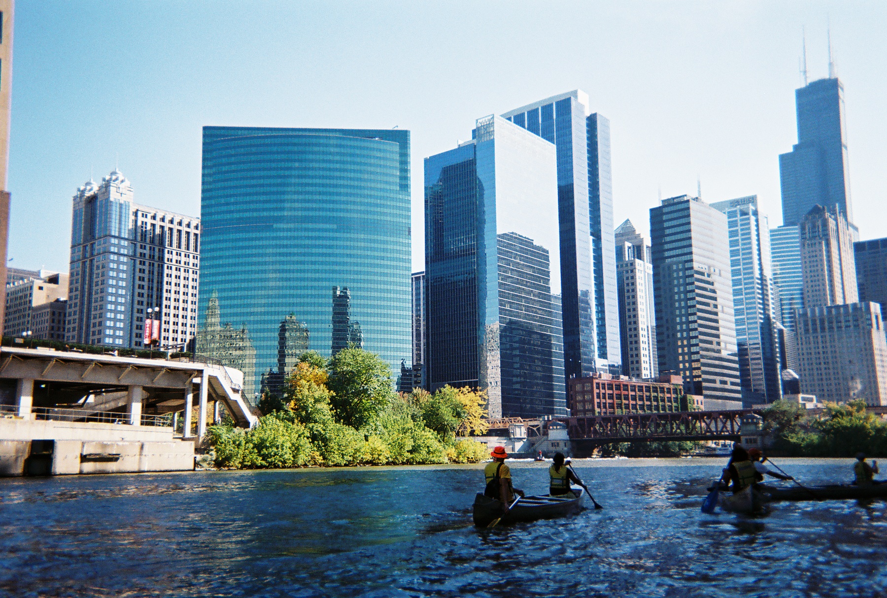
On Saturday, October 11th, students in my SUST 220 Water and PLS 391 Seminar in Natural Science classes at Roosevelt University took a canoe trip with me on the North Branch of the River, from Goose Island on the near-North Side of the city to Wolf Point in the heart of Chicago’s Loop — the place where the North Branch meets the South Branch, and ground zero in the history of Chicago’s development from a frontier town to a world metropolis. Our trip was led by expert river guides with the Friends of the Chicago River organization, which has long advocated for the conservation of the river and helped raise its public profile since the late 1970s.
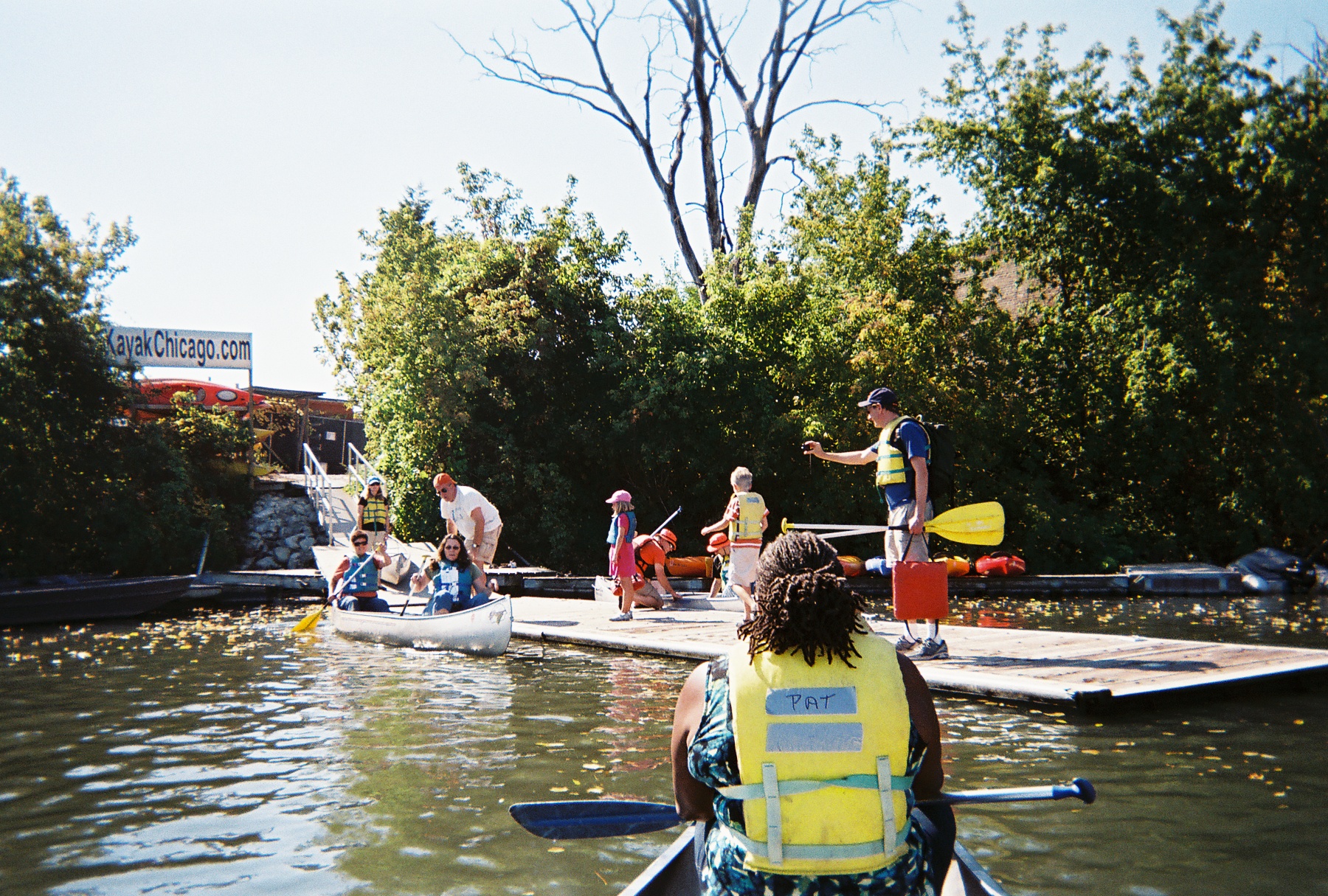
This was the fourth such trip I’ve taken with my RU students since the spring of 2009, the previous three trips taking place on Bubbly Creek, a notoriously-polluted tributary of the South Branch that for many decades absorbed the waste from the Chicago Stockyards. These field experiences give us a chance to explore urban nature first-hand and think about
- how water moves through those ecosystems and sustains their biotic communities;
- what kinds of pressures urban or suburban development exert upon these ecosystems;
- the impact of such pressures on water quality, flooding, etc.;
- conservation and/or restoration strategies that can improve the quality and sustainability of these aquatic ecosystems;
- the significance of water quality to the overall sustainability of urban systems, both in terms of nature and people.
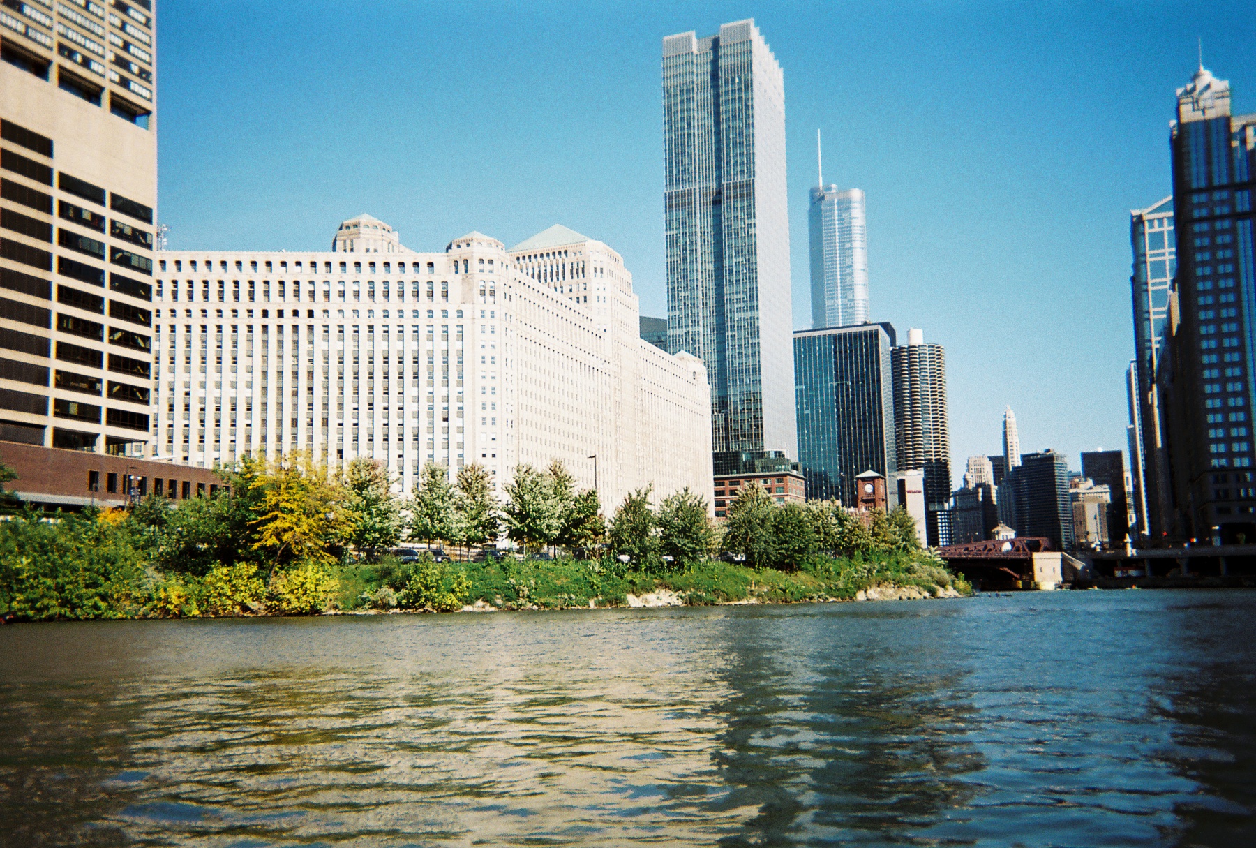
Our trip began at a canoe/kayak launch site at the turning basin at North Avenue, the widest spot along the entire Chicago river system. We proceeded down the North Branch, which runs along the west bank of Goose Island — itself a fascinating place in Chicago’s geographic and cultural history that was made an island when industrialist (and later Chicago’s first mayor) William Ogden had a canal dug to the east to excavate clay for brickmaking and to increase the area’s industrial waterfrontage.

Once home to Irish immigrants who kept geese and other livestock on their property, Goose Island has seen successive waves of industry and residential development over the decades; in this sense, it is a microcosm of Chicago’s own dynamic development as an industrial city. Since the late 1990s and early 2000s, it has become a thriving Planned Manufacturing District.
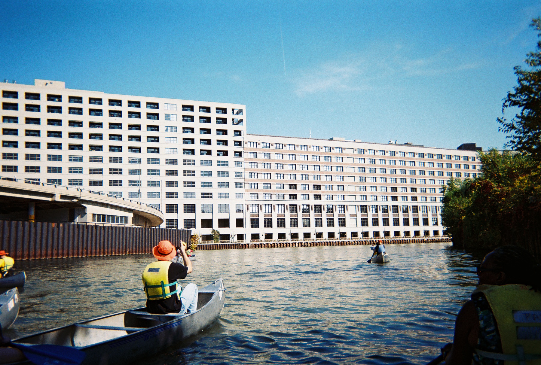
As we paddled southward toward Chicago’s Loop and passed the southern tip of goose Island, we learned to keep well to the right of the river channel to avoid the many tour boats and private craft that ply these waters. The presence of many diverse watercraft on the river testifies to its importance as a cultural and recreational amenity as well as tourist attraction — all of which have positive economic impacts for the city. The water here offers stunning views of bridges, factories, residential developments, and other waterfront properties — such as the massive Montgomery Ward catalog warehouse built in 1908 — which together constitute a colorful tapestry of the urban landscape.
The presence of urban wildlife in the river corridor, including numerous Canadian geese and Mallard duck sightings as well as evidence of beaver activity, highlight the river’s identity as a living ecosystem and value as wildlife habitat. This green face of the river was particularly evident in the North Branch Canal (east of Goose Island), through which we paddled on our way back from Wolf Point.
Those ecological musings are complicated by consideration of the many Combined Sewage Outfalls (CSOs) that exist along the riverbank, outlets that frequently release untreated sewage directly into the river in times when precipitation exceeds a certain threshold (about a half-inch, depending upon size of the area experiencing rainfall). These outfalls are not confined to industrial sections of the river; 265 of them occur all along the length of the Chicago Area Waterway System (CAWS),
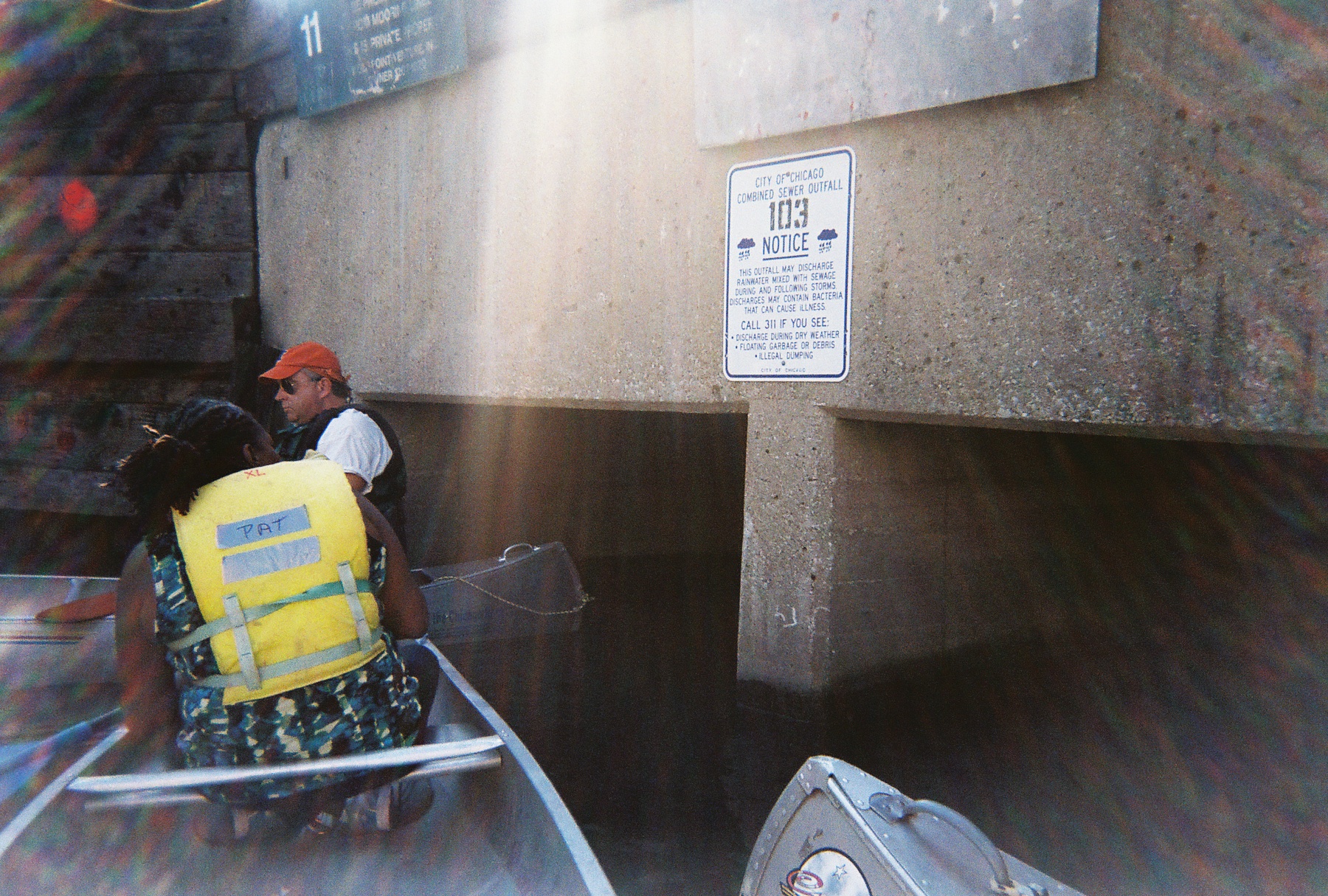
including this industrial yet scenic stretch of the North Branch and at the confluences of the North and South Branches in the Loop. Paddling near such an outflow is a disquieting and disturbing experience, as it brings one face-to-face with the question, “where does our waste go when we flush our toilets?” The answer: right here, quite often.
Indeed, the fecal coliform test we performed later at our canoe launch site confirmed the presence of (though did not quantify) coliform bacteria colonies in the water, which are indicators of fecal coliform — despite the fact that it had not rained in several days prior to our trip. Students also performed a variety of other water quality tests for physical and chemical variables such as temperature, turbidity (cloudiness), pH, hardness, dissolved oxygen, nitrate, phosphate, and chlorine. (You can view a summary of our results here as a pdf.)
Such a profile gives us a snapshot of the water quality at a given moment in time. In this case, overall quality was deemed fair to decent by such measures as temperature, pH, and dissolved oxygen; but elevated nitrate and phosphate levels (nutrients that result from industrial and urban pollution that can cause algal blooms and subsequent oxygen depletion) as well as the water’s fairly turbid nature and the definitive presence of coliform bacteria show there is much room for improvement. Had it rained that day or the previous day, many of these chemical indicators would’ve been measurably worse. Fortunately, the Metropolitan Water Reclamation District (MWRD) has recently moved to begin planning a final stage of disinfection for treated wastewater at two of its treatment plants, a move that will certainly lessen the chronic bacterial contamination of the water.
Paddling a polluted urban waterway is decidedly much different than journeying along a pristine stream in an uninhabited wilderness. But it may be an unparalleled way to way to experience a city’s landscape and to contemplate the complex processes of urban ecology represented by the movement of water with that landscape.
Mike,
great article and stellar pictures. It is always a pleasure having you and your students on the River.
Chris Parson
Thanks, Chris. Appreciate your expert guidance on the river — you guys are terrific, and the students really appreciate the context you provide about Chicago’s hydrological and cultural history. The body-as-map was particularly entertaining!
Mike